Not a motorcycling trip, but a great hiking adventure.
I’d dreamed of climbing the biggest mountain in Chiang Rai for years. Being in my home province, it was on the bucket list. But there are no roads to the top and knowing it was a 4 day walk to get there and back, with 3 nights camping, I had previously thought it was about impossible, especially for those in their sixties.... But after climbing Doi Wiang Pha last year (further north on the Khun Tan Mountain range and a 3 day hike), I felt confident I could probably do it.

Doi Langhka Luang is the highest mountain on the Khun Tan range, which runs roughly from the Kok River valley west of Chiang Rai, in a southerly direction down the east side of Chiang Mai and then swings in a southwesterly direction, then south again down to Doi Tao Lakes.
The hiking route went south, following the provincial borders; first between Chiang Rai and Chiang Mai. Then at Doi Langkha Luang, between Lampang and Chiang Mai.
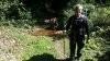
I had ridden the KLX down the Mae Kachan Hot springs, just north of the Khun Chae National Park HQ.

Some interesting statues around...
DAY 1;
Next morning, down to the park HQ.
We then took a 6klm ride in a pickup, southwest along the 118 and then turned left on a small road at the provincial border, that leads to a radar station. The hike started at a clearing nearby. 17 klms total hiking distance. Sounds easy over 4 days.......... Yeah right......!
Gary, my old windsurfing mate from 30 years ago in Pattaya, had agreed to come too. We had to carry camping gear plus food and some water for 4 days. Both of us were doing some training before the trip. Walking up and down a set of several hundred temple steps with a loaded pack several times, every couple of days, did help a bit.
Khun Chan the guide and Joy the sherpa (Muser from the royal project near Doi Mot) would accompany us.
There was an opportunity to top up the water bottles each day from mountain streams. Joy's job was to carry most of the water and collect firewood. Gary and I had cut out all spare items and luxuries and even with just basic equipment and food, the backpacks weighed about 13 kgs each, on the first day. That is about as heavy as you want on your back, when climbing steep mountain trails.
Off we go.... and it got steep almost straight away....
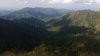
Walking along the ridges was to be the way, for most of the hike.
We were so lucky with the weather. It had been raining for about a week beforehand, so everywhere was pretty green and the views in the clean air were fantastic. We could clearly see the great mound of Doi Inthanon, over 100 klms away to the west.
Steep sides either side of the ridges, with often a treacherous drop, if you walked off the trail.

We could now see where we were heading. Doi Langkha Luang in sight, over a day's hike and several steep valleys away.
Wonderful views.

Resting on a ridge.
I tried Joy's backpack basket...... but my neck is too long....

By mid afternoon, we reached the campsite, in a forest clearing below the ridge.
After putting the hammocks up, it was time for dinner.
I had started camping again in 2016 and all last year had been carrying and warming up ready meals from Tesco Lotus and 7-11. But they never seemed to taste that good, so for this trip, I had decided to carry more fresh food. I had taken a pack of frozen sausages and frozen salmon fillets, wrapped up several cloths and a padded envelope for insulation. This idea worked very well and even after a day’s hike, it was all still frozen at dinner time.

Camping fine cuisine. Salmon fillets, baked potatoes and boiled veggies. I had 3 minute microwaved the spuds at home, and then they went in the camp fire in aluminium foil for 20 minutes.
DAY 2;
Had a bag of garlic naan bread with me too. That with good pork sausages, cooked on a stick, was for day 2 breakfast.
Gary and I were both using Hennessy hammocks.
We set off up a super steep mountainside. Slippery in the morning dew too.
Had a great view of the natural fortress of Doi Chiang Dao, 70 klms northwest.
Looking back north at the mountain we had hiked over, the day before.
After the very steep climb we popped out onto the small mound top of Doi PaNgom at 1700m. This was the first of the three high mountains we would climb.
Doi Langkha Luang looking a little closer now. We would reach camp 2 late afternoon that day, in the trees below the peak.
Looking southwest into the hazy valley of Chiang Mai.
Smoked ham with wasabi mustard, my home-made multigrain bread and boiled egg, for lunch.

An unusual sight, "kanun din". Ground jackfuit ? Each one about 2" in diameter.
Very fresh civet poo....
Camp 2 and we had decided to try pitching the hammocks on the ground. This works well, like a bivouac.
DAY 3;
Next morning, we were up at 05:00, to hike up to the top of Doi Langkha Luang for sunrise.
Looking west at the lights of Chiang Mai.
It was about 8 degrees C on the top of the mountain with a steady cold breeze.
Looking across at Doi Langkha Luang, in Chiang Rai. We were at first, on a second peak, about 200m to the southwest and about 30m lower, at the junction of Chiang Rai province, Chiang Mai province and Lampang province. This is where the mountain ridges come together. The provincial borders all follow the ridges. It also where the three National Parks meet. Khun Chae park in Chiang Rai, Mae Takhrai park in Chiang Mai and Chaeson park in Lampang. This means it is a huge area of natural forest and mountains, in every direction.
We then walked across to the top of the big mountain. Quite an achievement indeed and personal for me. The summit of Doi Langkha Luang at 2031m. Highest mountain in Chiang Rai and 5th highest mountain in Thailand. 2 days hike on steep mountains to get there and it would be 2 days to get back out too.
A privilege, to be able to see the sights we were seeing, that few people get to see.
The remains of a Thai Air Force helicopter that crashed into the side of Doi Luang Langkha, about 30 years ago.
Looking southwest along the Lampang/Chiang Mai ridge that we would walk on day 3. The far peak is Doi Langkha Noi and camp 3.
After breaking camp, time to walk again, 6klm of slightly easier walking today.
Looking back at Doi Langkha Luang from the southwest.
Panoramic view from southeast to northwest.

Ridges, ridges and more ridges..
Some lovely forested parts on day 3.
Doi Langkha Noi ahead.
After lunch we came to a clearing and it was time for a bit of a wash, after 3 days it felt really good........ Yep...cold water alright....
A natural lean-to shelter someone had used recently.
Lots of beautiful big trees enroute.
Doi Langkha Noi (1750m) finally looking a bit closer.
Camp 3 and drying some of the kit we washed in the waterfall.
After setting up camp below the summit, we took a late afternoon walk up to Doi Langkha Noi.
Looking back northeast to Doi Langkha Luang.
On the summit of Doi Langkha Noi.
The view across the Chaeson National park in Lampang. We could also see the ragged shape of the temple mountain of Wat Chalerm Prakiat, to the southwest, near Chaehom.
Gary was tempted to eat some raw edible roots...... but only slightly....
Back at camp, I managed to cook a Gaeng Keow Wahn green curry with ham, together with boiled rice and naan bread. Actually not that difficult using green curry powder, coconut powder, chopped smoked ham and fresh veggies. It tasted surprisingly good too...
DAY 4;
After breaking camp, we headed back up Doi Langkha Noi.
The guide had wanted us to take an "extremely steep" path, cut into the almost vertical southern end of Doi Langkha Noi. Gary and I baulked at this idea and told him we would take instead, just the "very steep" path down on the eastern face of the bluff. This was scary enough with a big pack on your back... and loose stones on the path.
Doi Langkha Noi from Google Earth

Looking around the southern tip of the bluff....
....and looking back up to Doi Langkha Noi about 100m above us.
Looking back again, as we headed southwest down into the valley.
More super steep sided ridges we walked along.
Down, down, down and then down some more....
Can now make out our final destination, a small village.
Lunch was the last of my multigrain bread with smoked salmon...
Finally we got down into the valley after midday and a quick cool off wash in the stream was great.
The last stop. The small coffee shop in the village of Mae Dton Luang, just off the 1252 that comes up from Chaeson to the 118.
The best part about the shop was a chair to sit......!
What a superb trip!
Most satisfying to have conquered this mountain and great to be out camping wild for a few days in nature. It had cost us about 3000 Baht each, for the pickup transport, guide and sherpa services, NP charge, insurance and tips. Good value for what we got. Chan & Joy did a great job and were most helpful.
We said or goodbyes and I headed back north to soak in a most welcome hot mineral bath at Mae Kachan Hot Springs.
I’d dreamed of climbing the biggest mountain in Chiang Rai for years. Being in my home province, it was on the bucket list. But there are no roads to the top and knowing it was a 4 day walk to get there and back, with 3 nights camping, I had previously thought it was about impossible, especially for those in their sixties.... But after climbing Doi Wiang Pha last year (further north on the Khun Tan Mountain range and a 3 day hike), I felt confident I could probably do it.
Doi Langhka Luang is the highest mountain on the Khun Tan range, which runs roughly from the Kok River valley west of Chiang Rai, in a southerly direction down the east side of Chiang Mai and then swings in a southwesterly direction, then south again down to Doi Tao Lakes.
The hiking route went south, following the provincial borders; first between Chiang Rai and Chiang Mai. Then at Doi Langkha Luang, between Lampang and Chiang Mai.
I had ridden the KLX down the Mae Kachan Hot springs, just north of the Khun Chae National Park HQ.
Some interesting statues around...
DAY 1;
Next morning, down to the park HQ.
We then took a 6klm ride in a pickup, southwest along the 118 and then turned left on a small road at the provincial border, that leads to a radar station. The hike started at a clearing nearby. 17 klms total hiking distance. Sounds easy over 4 days.......... Yeah right......!
Gary, my old windsurfing mate from 30 years ago in Pattaya, had agreed to come too. We had to carry camping gear plus food and some water for 4 days. Both of us were doing some training before the trip. Walking up and down a set of several hundred temple steps with a loaded pack several times, every couple of days, did help a bit.
Khun Chan the guide and Joy the sherpa (Muser from the royal project near Doi Mot) would accompany us.
There was an opportunity to top up the water bottles each day from mountain streams. Joy's job was to carry most of the water and collect firewood. Gary and I had cut out all spare items and luxuries and even with just basic equipment and food, the backpacks weighed about 13 kgs each, on the first day. That is about as heavy as you want on your back, when climbing steep mountain trails.
Off we go.... and it got steep almost straight away....
Walking along the ridges was to be the way, for most of the hike.
We were so lucky with the weather. It had been raining for about a week beforehand, so everywhere was pretty green and the views in the clean air were fantastic. We could clearly see the great mound of Doi Inthanon, over 100 klms away to the west.
Steep sides either side of the ridges, with often a treacherous drop, if you walked off the trail.
We could now see where we were heading. Doi Langkha Luang in sight, over a day's hike and several steep valleys away.
Wonderful views.
Resting on a ridge.
I tried Joy's backpack basket...... but my neck is too long....
By mid afternoon, we reached the campsite, in a forest clearing below the ridge.
After putting the hammocks up, it was time for dinner.
I had started camping again in 2016 and all last year had been carrying and warming up ready meals from Tesco Lotus and 7-11. But they never seemed to taste that good, so for this trip, I had decided to carry more fresh food. I had taken a pack of frozen sausages and frozen salmon fillets, wrapped up several cloths and a padded envelope for insulation. This idea worked very well and even after a day’s hike, it was all still frozen at dinner time.
Camping fine cuisine. Salmon fillets, baked potatoes and boiled veggies. I had 3 minute microwaved the spuds at home, and then they went in the camp fire in aluminium foil for 20 minutes.
DAY 2;
Had a bag of garlic naan bread with me too. That with good pork sausages, cooked on a stick, was for day 2 breakfast.
Gary and I were both using Hennessy hammocks.
We set off up a super steep mountainside. Slippery in the morning dew too.
Had a great view of the natural fortress of Doi Chiang Dao, 70 klms northwest.
Looking back north at the mountain we had hiked over, the day before.
After the very steep climb we popped out onto the small mound top of Doi PaNgom at 1700m. This was the first of the three high mountains we would climb.
Doi Langkha Luang looking a little closer now. We would reach camp 2 late afternoon that day, in the trees below the peak.
Looking southwest into the hazy valley of Chiang Mai.
Smoked ham with wasabi mustard, my home-made multigrain bread and boiled egg, for lunch.
An unusual sight, "kanun din". Ground jackfuit ? Each one about 2" in diameter.
Very fresh civet poo....
Camp 2 and we had decided to try pitching the hammocks on the ground. This works well, like a bivouac.
DAY 3;
Next morning, we were up at 05:00, to hike up to the top of Doi Langkha Luang for sunrise.
Looking west at the lights of Chiang Mai.
It was about 8 degrees C on the top of the mountain with a steady cold breeze.
Looking across at Doi Langkha Luang, in Chiang Rai. We were at first, on a second peak, about 200m to the southwest and about 30m lower, at the junction of Chiang Rai province, Chiang Mai province and Lampang province. This is where the mountain ridges come together. The provincial borders all follow the ridges. It also where the three National Parks meet. Khun Chae park in Chiang Rai, Mae Takhrai park in Chiang Mai and Chaeson park in Lampang. This means it is a huge area of natural forest and mountains, in every direction.
We then walked across to the top of the big mountain. Quite an achievement indeed and personal for me. The summit of Doi Langkha Luang at 2031m. Highest mountain in Chiang Rai and 5th highest mountain in Thailand. 2 days hike on steep mountains to get there and it would be 2 days to get back out too.
A privilege, to be able to see the sights we were seeing, that few people get to see.
The remains of a Thai Air Force helicopter that crashed into the side of Doi Luang Langkha, about 30 years ago.
Looking southwest along the Lampang/Chiang Mai ridge that we would walk on day 3. The far peak is Doi Langkha Noi and camp 3.
After breaking camp, time to walk again, 6klm of slightly easier walking today.
Looking back at Doi Langkha Luang from the southwest.
Panoramic view from southeast to northwest.
Ridges, ridges and more ridges..
Some lovely forested parts on day 3.
Doi Langkha Noi ahead.
After lunch we came to a clearing and it was time for a bit of a wash, after 3 days it felt really good........ Yep...cold water alright....
A natural lean-to shelter someone had used recently.
Lots of beautiful big trees enroute.
Doi Langkha Noi (1750m) finally looking a bit closer.
Camp 3 and drying some of the kit we washed in the waterfall.
After setting up camp below the summit, we took a late afternoon walk up to Doi Langkha Noi.
Looking back northeast to Doi Langkha Luang.
On the summit of Doi Langkha Noi.
The view across the Chaeson National park in Lampang. We could also see the ragged shape of the temple mountain of Wat Chalerm Prakiat, to the southwest, near Chaehom.
Gary was tempted to eat some raw edible roots...... but only slightly....
Back at camp, I managed to cook a Gaeng Keow Wahn green curry with ham, together with boiled rice and naan bread. Actually not that difficult using green curry powder, coconut powder, chopped smoked ham and fresh veggies. It tasted surprisingly good too...
DAY 4;
After breaking camp, we headed back up Doi Langkha Noi.
The guide had wanted us to take an "extremely steep" path, cut into the almost vertical southern end of Doi Langkha Noi. Gary and I baulked at this idea and told him we would take instead, just the "very steep" path down on the eastern face of the bluff. This was scary enough with a big pack on your back... and loose stones on the path.
Doi Langkha Noi from Google Earth
Looking around the southern tip of the bluff....
....and looking back up to Doi Langkha Noi about 100m above us.
Looking back again, as we headed southwest down into the valley.
More super steep sided ridges we walked along.
Down, down, down and then down some more....
Can now make out our final destination, a small village.
Lunch was the last of my multigrain bread with smoked salmon...
Finally we got down into the valley after midday and a quick cool off wash in the stream was great.
The last stop. The small coffee shop in the village of Mae Dton Luang, just off the 1252 that comes up from Chaeson to the 118.
The best part about the shop was a chair to sit......!
What a superb trip!
Most satisfying to have conquered this mountain and great to be out camping wild for a few days in nature. It had cost us about 3000 Baht each, for the pickup transport, guide and sherpa services, NP charge, insurance and tips. Good value for what we got. Chan & Joy did a great job and were most helpful.
We said or goodbyes and I headed back north to soak in a most welcome hot mineral bath at Mae Kachan Hot Springs.