Doi Nork is a massive, symmetrical, virtually completely bare, grey black rock.
Easy to see, when riding south, in to Phayao on highway 1, or from the Lampang side of road 120, between Mae Kachan and Phayao.
It is in the Doi Luang National Park and sits on the ridge line forming the border between Lampang and Phayao provinces.
It is also marked on the GTR Golden Triangle map.
A “Nork” is the large shoulder hump on an Indian cow.

For many years I would look for it when riding the 120, considering how I could get up there, to see it up close.
Finally, the day came…… and it was to be well worth waiting for....
On google Earth it looks like…..

….. and is here
The closest access is from the Thai Lue village of Pong Tham, off the 120. In fact there are big signs for Doi Nork at the turn off to the village.
I had visited Pong Tham and found the Phu Yai Bahn, Khun Sanae, last month. After a good chat, he advised he would arrange a guide for a hike up to the Nork. Then I called him a few days before I wanted to go, when the weather looked OK.
After staying in Wang Nuea for the night, I rode into Pong Tham at 08:00, to Khun Sanae’s house (I think the only concrete house in the village). My experienced guide was to be Khun Pan.

We left by bike at 08:30 and immediately got into a wonderful dirt trail, with several river crossings.
The villagers were heading off on tractors & E-Dtens, to work in the fields.
Some great fun river riding.... just gun it and hope you don't hit a big rock.....
After 3.5klms of great dirt riding, we reached the first of three cleared resting areas. Some hikers walk from the village, other take an E-Dten ride. Dirt bike to here is the best way though, of course…
We parked up the bikes and started the 3-4 hour hike up to the ridge.
It was pretty steep from the very start….. this was going to be tough…
A large tree with bamboo ladder, to collect bee hives.
Some trail clearing to do enroute.
Lanna Thai “Go for water, 120 steps north”
There were three resting places in all. After what seemed like many hours, we reached base camp. Khun Pan grabbed a couple of sleeping mats and 3 empty 1 litre water bottles.
On we go..
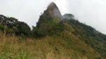
Soon, we got the first up close look at the Nork.
Imposing and massive indeed.
Getting pretty tough here, thick jungle and large boulders to climb over...
The highest water source. Clean, fresh and cool.
There was no place to get water after this, so I drank as much as possible and filled my 3 litre bladder to the top, plus a ½ litre plastic bottle. It was just enough for 24 hours.
The last stretch was particularly steep.... luckily it was cool, as we had light rain from being in the clouds
Then finally, we were up onto the ridge.... the Lampang / Phayao border
My legs were throbbing..... but there was lots more to come yet....
The leech socks worked and I did pull off a few of the little buggers. Leech socks don’t stop them climbing up your leg, they just make them easier to see….
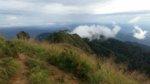
Standing in the clouds.....
Unfortunately, the Nork was lost in the mist to the southeast……..
…….but then…..
… it appeared…..
… dark and foreboding…..
We hiked towards it.....
… after starting to climb, I decided this was just too scary and downright dangerous…… I told Pan I wasn’t going up to the top….
….. then I thought of later having to answer the question…. “Did you get to the top?”…
Luckily perhaps, the mist closed in again….
… so OK… let’s roll….
The only way was to pull yourself up on this steel wire…..! .... and I didn't feel much like Spiderman.. it was damn scary......
Finally, we were on the top of the world….. What an incredible place to be…!
Looking over the southeast edge.. There were no views due to the mist, definitely a good thing for me…. I don’t like heights…
After gingerly descending...... clutching the wire rope...! we were back to the ridge and scrambling across below the southwest flank of the Nork.
Looking up, perhaps halfway across....
.... more tough clambering over and around huge rocks...
After about 20 minutes, we had made it to the other end of the Nork.
Now, the plan was to hike for another 2 hours to Doi Luang, a higher peak further along the ridge to the southeast.
...gaps in the mist
My legs were now almost crying......
But finally made it...... Doi Luang, 1,694m altitude.
I pitched my little tent right at the summit... fantastic.
By late afternoon the mist had cleared.... but the Nork was still trying to hide...
Looking down into Lampang
Further SSE down the ridge
Looking the other way, down onto Gwan Phayao
We could see the shape of Chalerm Prakiat, Jaeson, Lampang
I was tired and hungry, so cooked up some gaeng kiow wahn gai with rice for dinner and soon crashed into my sleeping bag..
The night lights of Phayao (poor photo, it was actually a wonderful view).
We woke to a beautiful morning..... and temperature of 16 deg C.
From the campsite at the summit of Doi Luang, we could see;
Phayao - Highway 1 and Gwan Phayao to the NE and across to the mountains in the Phu Nang NP, also the viewpoint on the 120 to the SE.
Lampang - Chalerm Prakiat and Jaeson NP to the SW, also down to Wang Nuea.
Chiang Rai - Doi Langka Luang in Khun Chae NP to the W, also the Hot Spring area at Pong Nam Ron and Mae Kachan, up to Wiang Papao.
Chiang Mai - Doi Chiang Dao to NW (unmistakable shape in the far distance).
After coffee, we broke camp and hiked back northwest along the ridge
Looking down to village of Pong Tham, where we had started the trip, to the right of the white chicken farm buildings.
we got some stunning views of the Nork as we approached it.....
So...... How big is it..?
....difficult to say.
I’m going guess at 150m high, of bare rock each side in the middle and perhaps 200m long at the base. The little wat on the summit is about 2.5m high.
It is a natural wonder of Thailand. But little known and little visited, although the number of people climbing it, is increasing every year.
On the New Year holiday, Pan told me there may be 50 people on the ridge, having hiked from Lampang side, or Phayao side, or from the bottom of the ridge on the 120.
Last view of this amazing rock..
Then it was a left turn and a steep 2.5 hour hike down
After a welcome shower at the Phu Yai Bahn's house, I received my certificate, signed by the Lampang Governor.......!
... Apparently, for farangs, only a couple of Swiss have been up before and I was the first Englishman to have sumitted.

I dropped in to the Lanna Onsen hot mineral spring bath on the way home, to ease the aching muscles........ superb....
Now, 2 days later, my legs are still aching, but the sense of achievement will remain for a very long time....
Easy to see, when riding south, in to Phayao on highway 1, or from the Lampang side of road 120, between Mae Kachan and Phayao.
It is in the Doi Luang National Park and sits on the ridge line forming the border between Lampang and Phayao provinces.
It is also marked on the GTR Golden Triangle map.
A “Nork” is the large shoulder hump on an Indian cow.
For many years I would look for it when riding the 120, considering how I could get up there, to see it up close.
Finally, the day came…… and it was to be well worth waiting for....
On google Earth it looks like…..
….. and is here
The closest access is from the Thai Lue village of Pong Tham, off the 120. In fact there are big signs for Doi Nork at the turn off to the village.
I had visited Pong Tham and found the Phu Yai Bahn, Khun Sanae, last month. After a good chat, he advised he would arrange a guide for a hike up to the Nork. Then I called him a few days before I wanted to go, when the weather looked OK.
After staying in Wang Nuea for the night, I rode into Pong Tham at 08:00, to Khun Sanae’s house (I think the only concrete house in the village). My experienced guide was to be Khun Pan.
We left by bike at 08:30 and immediately got into a wonderful dirt trail, with several river crossings.
The villagers were heading off on tractors & E-Dtens, to work in the fields.
Some great fun river riding.... just gun it and hope you don't hit a big rock.....
After 3.5klms of great dirt riding, we reached the first of three cleared resting areas. Some hikers walk from the village, other take an E-Dten ride. Dirt bike to here is the best way though, of course…
We parked up the bikes and started the 3-4 hour hike up to the ridge.
It was pretty steep from the very start….. this was going to be tough…
A large tree with bamboo ladder, to collect bee hives.
Some trail clearing to do enroute.
Lanna Thai “Go for water, 120 steps north”
There were three resting places in all. After what seemed like many hours, we reached base camp. Khun Pan grabbed a couple of sleeping mats and 3 empty 1 litre water bottles.
On we go..
Soon, we got the first up close look at the Nork.
Imposing and massive indeed.
Getting pretty tough here, thick jungle and large boulders to climb over...
The highest water source. Clean, fresh and cool.
There was no place to get water after this, so I drank as much as possible and filled my 3 litre bladder to the top, plus a ½ litre plastic bottle. It was just enough for 24 hours.
The last stretch was particularly steep.... luckily it was cool, as we had light rain from being in the clouds
Then finally, we were up onto the ridge.... the Lampang / Phayao border
My legs were throbbing..... but there was lots more to come yet....
The leech socks worked and I did pull off a few of the little buggers. Leech socks don’t stop them climbing up your leg, they just make them easier to see….
Standing in the clouds.....
Unfortunately, the Nork was lost in the mist to the southeast……..
…….but then…..
… it appeared…..
… dark and foreboding…..
We hiked towards it.....
… after starting to climb, I decided this was just too scary and downright dangerous…… I told Pan I wasn’t going up to the top….
….. then I thought of later having to answer the question…. “Did you get to the top?”…
Luckily perhaps, the mist closed in again….
… so OK… let’s roll….
The only way was to pull yourself up on this steel wire…..! .... and I didn't feel much like Spiderman.. it was damn scary......
Finally, we were on the top of the world….. What an incredible place to be…!
Looking over the southeast edge.. There were no views due to the mist, definitely a good thing for me…. I don’t like heights…
After gingerly descending...... clutching the wire rope...! we were back to the ridge and scrambling across below the southwest flank of the Nork.
Looking up, perhaps halfway across....
.... more tough clambering over and around huge rocks...
After about 20 minutes, we had made it to the other end of the Nork.
Now, the plan was to hike for another 2 hours to Doi Luang, a higher peak further along the ridge to the southeast.
...gaps in the mist
My legs were now almost crying......
But finally made it...... Doi Luang, 1,694m altitude.
I pitched my little tent right at the summit... fantastic.
By late afternoon the mist had cleared.... but the Nork was still trying to hide...
Looking down into Lampang
Further SSE down the ridge
Looking the other way, down onto Gwan Phayao
We could see the shape of Chalerm Prakiat, Jaeson, Lampang
I was tired and hungry, so cooked up some gaeng kiow wahn gai with rice for dinner and soon crashed into my sleeping bag..
The night lights of Phayao (poor photo, it was actually a wonderful view).
We woke to a beautiful morning..... and temperature of 16 deg C.
From the campsite at the summit of Doi Luang, we could see;
Phayao - Highway 1 and Gwan Phayao to the NE and across to the mountains in the Phu Nang NP, also the viewpoint on the 120 to the SE.
Lampang - Chalerm Prakiat and Jaeson NP to the SW, also down to Wang Nuea.
Chiang Rai - Doi Langka Luang in Khun Chae NP to the W, also the Hot Spring area at Pong Nam Ron and Mae Kachan, up to Wiang Papao.
Chiang Mai - Doi Chiang Dao to NW (unmistakable shape in the far distance).
After coffee, we broke camp and hiked back northwest along the ridge
Looking down to village of Pong Tham, where we had started the trip, to the right of the white chicken farm buildings.
we got some stunning views of the Nork as we approached it.....
So...... How big is it..?
....difficult to say.
I’m going guess at 150m high, of bare rock each side in the middle and perhaps 200m long at the base. The little wat on the summit is about 2.5m high.
It is a natural wonder of Thailand. But little known and little visited, although the number of people climbing it, is increasing every year.
On the New Year holiday, Pan told me there may be 50 people on the ridge, having hiked from Lampang side, or Phayao side, or from the bottom of the ridge on the 120.
Last view of this amazing rock..
Then it was a left turn and a steep 2.5 hour hike down
After a welcome shower at the Phu Yai Bahn's house, I received my certificate, signed by the Lampang Governor.......!
... Apparently, for farangs, only a couple of Swiss have been up before and I was the first Englishman to have sumitted.
I dropped in to the Lanna Onsen hot mineral spring bath on the way home, to ease the aching muscles........ superb....
Now, 2 days later, my legs are still aching, but the sense of achievement will remain for a very long time....