The western stretch of 3004 takes off from 105 just 25 km south of Mae Sariang. It has everything from super nice asphalt curves to light dirt riding. 80 km to Mae Sam Laep where it meets 1194.
This trip I am doing on my girlfriends little MSX, 102 kilo and 10 horses! It suits my not so great riding skills. I added one inch bigger grippy tyres and a more comfortable touring seat. Maybe I should tell I am not an experienced rider, I used 50-125 cc bikes as daily transport when I was 15-17, then switched to cars. Now 40 years later in Thailand I am riding again.
Okay the 3004 starts at 170 meters altitude in Mae Suat off 105.
Up here at 900 meter a viewpoint with camping and coffee. There are more coffee shops along the route btw.

On the road again
Just after Ban Sue Mue you can take right on the now much improved former dirt track more directly west towards Kloselo mountain camping and viewpoints. Very popular among thais
Soon time for gravel and very steep sections downwards to the refugee camp area
Down to 100 meters elevation altitude in not that many km. Here some concrete, but no lack of dirt near the camp village. These Burmese fellas had a good uphill trek for sure!
Downwards and soon a muddy steep rocky slope where I was lucky to not meet a pickup
Camp village entrace. 5 min earlier I had a chat with a group of english speaking Burmese in a pickup, they told me I would probably not be allowed to pass, but that was no problem. It reminds me of the privilege of being born in a western country.
Main street in village
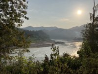
Out west from village. This river flows down to the Yuam river, not far away. Which in turn soon joins the Moei river. Next time I will turn left and check out some riverbed riding there.

3004 up north from the village. I said good bye the friendly camp commanders
Soon a occasional section of paved road
Always an eternity of work with landslides and directing water flow here up north
Here I choose to leave 3004 and have a look at the mountain camping areas
One of many forks and crossroad junctions up here
Up on one of the viewpoint- and camping sites. About 900-1000 meters up.
ok Iwill now take a break posting before my tablet crashes
This trip I am doing on my girlfriends little MSX, 102 kilo and 10 horses! It suits my not so great riding skills. I added one inch bigger grippy tyres and a more comfortable touring seat. Maybe I should tell I am not an experienced rider, I used 50-125 cc bikes as daily transport when I was 15-17, then switched to cars. Now 40 years later in Thailand I am riding again.
Okay the 3004 starts at 170 meters altitude in Mae Suat off 105.
Up here at 900 meter a viewpoint with camping and coffee. There are more coffee shops along the route btw.
On the road again
Just after Ban Sue Mue you can take right on the now much improved former dirt track more directly west towards Kloselo mountain camping and viewpoints. Very popular among thais
Soon time for gravel and very steep sections downwards to the refugee camp area
Down to 100 meters elevation altitude in not that many km. Here some concrete, but no lack of dirt near the camp village. These Burmese fellas had a good uphill trek for sure!
Downwards and soon a muddy steep rocky slope where I was lucky to not meet a pickup
Camp village entrace. 5 min earlier I had a chat with a group of english speaking Burmese in a pickup, they told me I would probably not be allowed to pass, but that was no problem. It reminds me of the privilege of being born in a western country.
Main street in village
Out west from village. This river flows down to the Yuam river, not far away. Which in turn soon joins the Moei river. Next time I will turn left and check out some riverbed riding there.
3004 up north from the village. I said good bye the friendly camp commanders
Soon a occasional section of paved road
Always an eternity of work with landslides and directing water flow here up north
Here I choose to leave 3004 and have a look at the mountain camping areas
One of many forks and crossroad junctions up here
Up on one of the viewpoint- and camping sites. About 900-1000 meters up.
ok Iwill now take a break posting before my tablet crashes