
With Songkran madness going on in my village and all along the highway to Tha Ton I thought I'd take the chance of the last few dry days ( we hope its going to rain soon) to have a go at the Kok River south bank side from Mae Salak to Pha Soet. And the news is its possible but probably only till its rains. To be quite honest this was just a thing to be done because its there. I live nearby and just wanted to see where the bikes and pick-ups that occasionally come out at Mae Salak come from. Its not a scenic route, especially in the recent pollution, but I doubt it would be impressive with blue skies and lush green vegetation and the awful condition of the road nibbles away at your enthusiasm.
 Right from the start at Mae Salak its broken old concrete that gives way to dirt and dust, comes back in bits and pieces then reverts to dirt again. Its well used, lots of villagers come out of here but for some reason, despite there abundant crops they are not worthy of a road. They were obviously amused and confused as to why this old farang was bothering to put up with it for no good reason.


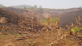
On the early flatter bits there was a lot of casava and a couple of rubber plantation, then as you got into the steeper valley there were signs of the recent fires that have blighted our lives for the last month. Almost surely this get planted with corn. There were some newly built constructions that had me thinking people were moving into the area to take advantage of land they could appropriate for themselves and a couple of decent sized Lahu villages of a more permanent style.
.jpg")
The Muser Daeng, (Red Lahu) at the seond village were friendly and amused to see a passer-by. It was here I stopped and asked is the route open to Chiang Rai and could I get through on an Exciter. This would have been turn around point if it was a definite no but they all agreed it was no problem, easy stuff. So I rattled on over the stones, the dust, the broken concrete and trusted their word. They found me funny. Not long after this the road turned away from the river to get over a small stream and looked to go up through a mountain pass but another dirt cutting had been made and took off along the rivers edge and I took that. Google maps kept wanting to plot me in the mountain direction when I was later trying to get a picture of the route so I can only assume the cutting along the river is newer or perhaps often closed. It is obviously a place prone to landslips and steep enough in places to be trouble in the wet.
Coming back down off the steep mountain side and nearer to Chiang Rai there was fields of crops, dirt roads heading into the hills and electricity posts just going in. Lots of activity taking place off a road that called out for improvement. This wasn't difficult terrain but home to hilltribes that maybe the government doesn't care for too much. A grader had been through, you could still see the tyre tracks and piles of standing dust that will be flattened in the rains were noticeable. Maybe a better road is coming soon.
I got a soaking from kids throwing water in the next village, a test of patience for a man boiled and bounced for 2 hours who didn't really need water to make the dust stick, then finally hit the small Aleaja suspension bridge which the locals obviously take their bikes across to make use of the much better quicker road into Chiang Rai. Soon after that was the sad site of the Lam Nam Kok National Park that looks like a failed enterprise with abandoned buildings and empty spaces. Somebody should have told them the average city Thai would rather spend a day in a shopping mall than in a forest by the river. The Pha Soet Spa took me by surprise because suddenly I come upon food stalls, restaurants and a small carpark with tourists after 3 hours of dust and dirt.
From here it was a proper road, still minor and twisting about and I passed the strangely named Doi Organic Park Buddhist Temple with a big walkway heading off up a hill which is just too much for a man with defect knees. The road exits onto the 131, the bypass west of Chiang Rai and I just had to stop and have a picture of the big beach scene from the bridge where the highway crosses the Kok. A thousand people doing their Songkran bit. Then it was the 90 kms back to Tha Ton passing the newly burning mountain forests just before Mae Chan. What is going on with all these arsonists?
On the early flatter bits there was a lot of casava and a couple of rubber plantation, then as you got into the steeper valley there were signs of the recent fires that have blighted our lives for the last month. Almost surely this get planted with corn. There were some newly built constructions that had me thinking people were moving into the area to take advantage of land they could appropriate for themselves and a couple of decent sized Lahu villages of a more permanent style.
The Muser Daeng, (Red Lahu) at the seond village were friendly and amused to see a passer-by. It was here I stopped and asked is the route open to Chiang Rai and could I get through on an Exciter. This would have been turn around point if it was a definite no but they all agreed it was no problem, easy stuff. So I rattled on over the stones, the dust, the broken concrete and trusted their word. They found me funny. Not long after this the road turned away from the river to get over a small stream and looked to go up through a mountain pass but another dirt cutting had been made and took off along the rivers edge and I took that. Google maps kept wanting to plot me in the mountain direction when I was later trying to get a picture of the route so I can only assume the cutting along the river is newer or perhaps often closed. It is obviously a place prone to landslips and steep enough in places to be trouble in the wet.
Coming back down off the steep mountain side and nearer to Chiang Rai there was fields of crops, dirt roads heading into the hills and electricity posts just going in. Lots of activity taking place off a road that called out for improvement. This wasn't difficult terrain but home to hilltribes that maybe the government doesn't care for too much. A grader had been through, you could still see the tyre tracks and piles of standing dust that will be flattened in the rains were noticeable. Maybe a better road is coming soon.
I got a soaking from kids throwing water in the next village, a test of patience for a man boiled and bounced for 2 hours who didn't really need water to make the dust stick, then finally hit the small Aleaja suspension bridge which the locals obviously take their bikes across to make use of the much better quicker road into Chiang Rai. Soon after that was the sad site of the Lam Nam Kok National Park that looks like a failed enterprise with abandoned buildings and empty spaces. Somebody should have told them the average city Thai would rather spend a day in a shopping mall than in a forest by the river. The Pha Soet Spa took me by surprise because suddenly I come upon food stalls, restaurants and a small carpark with tourists after 3 hours of dust and dirt.
From here it was a proper road, still minor and twisting about and I passed the strangely named Doi Organic Park Buddhist Temple with a big walkway heading off up a hill which is just too much for a man with defect knees. The road exits onto the 131, the bypass west of Chiang Rai and I just had to stop and have a picture of the big beach scene from the bridge where the highway crosses the Kok. A thousand people doing their Songkran bit. Then it was the 90 kms back to Tha Ton passing the newly burning mountain forests just before Mae Chan. What is going on with all these arsonists?
Attachments
Last edited:
