Exploring Southern Laos.

Mar 30, 2010
2,136
300
83
G'day All,

Jim and I headed over to Southern Laos again last month.
Absolute ripper of a trip and a great bloke to go riding with.

We wanted to do something different.. Not the normal tracks or now graded roads and stay in the same old Guest Houses.
This trip we planned to camp as much as needed and seek out new tracks and try and link up some different ways.

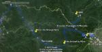
We leave Ubon and cross over at Chong Mek.
The road works on the Thai side are long completed.
Dual carriage way all the way to Chong Mek,

Vang Tao.. Big border crossing upgrade going on.
Has been going on for a while.. But this time when leaving.. you can really start to see it take shape.

Then the road is upgraded around 18km on the other side.. If I remember correctly.
Certainly not to the same standard as on the Thai side..
Much wider and maybe when they put lines on the road they can squeeze in dual carriage way.

Same routine as last time when we crossed with Justin.. First dirt road on the right and off we go.
Getting off that boring 45 min ride on the tarmac to Pakse.

Jim had done his homework. Plotted out a nice route to Pakse using Google Earth with dirt all the way to the bridge.

DSC_1439-X2.jpg


There was only one bit where we went through rice fields and sure the locals have a work around when the rains come.

Screen%20Shot%202558-03-24%20at%204.09.39%20PM.jpg


Screen%20Shot%202558-03-24%20at%203.25.28%20PM.jpg


DSC_1435-X2.jpg


Screen%20Shot%202558-03-24%20at%203.26.10%20PM.png


Screen%20Shot%202558-03-24%20at%203.32.10%20PM.png


Screen%20Shot%202558-03-24%20at%203.30.06%20PM.jpg


A nice easy crossing and a rumble through the back way we arrive at Pakse.

More to come.

Cheers
Brian
 
  • Like
Reactions: Yuri Orlov
Mar 30, 2010
2,136
300
83
The next day we wake up at a leisurely hour and head off to Tad Fane.
Jim plotted this one on Google Earth. Again the creative way avoiding as much tarmac as possible.

Screen%20Shot%202558-03-25%20at%203.18.18%20PM.jpg


We were not sure if we could get through.. Worse case scenario, go back and up to Paksong the boring way and stay the night

We did make it and if you look at the map where we join the tarmac for the last bit to Tad Fane. There is actually a trail to the right that will take you around to the entrance of Tad Fane. Have ridden this in the past.

We decided to push on the last few KM on the tarmac and get some food and decide if we give Pakse to Attapue a bash in one day.
If we don't make it and it gets dark.. Camp out along the way..

Last time we rode this in the rainy season around 18 months earlier there were plenty of places to camp with water source.

Lots and lots of rubber tree plantations after you leave Pakse.. Sad really as this would have all been lovely forest.

Screen%20Shot%202558-03-25%20at%202.38.32%20PM.jpg


Some kids along the way

DSC_1447-2-X2.jpg


Also some fun trails after leaving the rubber plantations.

Screen%20Shot%202558-03-25%20at%202.41.20%20PM.jpg


Magnificent views along the way

DSC_1450-X2.jpg


To our surprise we arrive at a gate... This is the entrance to a coffee plantation.
Luckily no padlocks and we let ourselves out.

Screen%20Shot%202558-03-25%20at%202.43.33%20PM.jpg


Screen%20Shot%202558-03-25%20at%202.44.20%20PM.jpg


Getting closer to Tad Fane..
We try to avoid the tarmac and see if we can follow the power lines running parallel with the road.

Screen%20Shot%202558-03-25%20at%202.40.03%20PM.jpg


Screen%20Shot%202558-03-25%20at%202.40.33%20PM.jpg


After a feed and a coffee at Tad Fane..
We decide to push on down to Attapue..
If we don't make it due to night fall we will camp.

Screen%20Shot%202558-03-25%20at%203.20.40%20PM.jpg


(Last time we did this road down this route to Attapue -
https://www.gt-rider.com/thailand-motorcycle-forum/showthread.php/38594-Wet-Season-No-Plans-Tour-Southern-Laos-Jun-Jul-2013 )

Second part of the days ride down to Attapue to come.

Cheers
Brian
 
Mar 30, 2010
2,136
300
83
Sadly this track has been totally destroyed by the road upgrade :-(

Now Dry Season.

Screen%20Shot%202558-03-25%20at%208.12.44%20PM.jpg


DSC_1455-X2.jpg


Before Rainy season.

DSCN6030_zps4bb84d0c.jpg


DSCN6037_zpsd1af4b0b.jpg


More current pictures

DSC_1456-X2.jpg


DSC_1458-X2.jpg


The wooden suspension bridge at the bottom is still a ripper.
Also in much better repair than before

Now
DSC_1460-XL.jpg


DSC_1461-XL.jpg


Even has hand railings now and no missing or skewed planks.

Screen%20Shot%202558-03-25%20at%208.17.09%20PM.jpg


Before

DSCN6091_zps8a804131.jpg


Riding the bridge

This time we decided to ride through the river as it was low enough and water crossings are fun too.

Screen%20Shot%202558-03-25%20at%208.18.48%20PM.jpg


River Crossing.

Getting closer to Route 18

Screen%20Shot%202558-03-25%20at%208.42.44%20PM.jpg


Very dusty and white out when trying to pass cars


The home stretch to Attapue.
Easy ride in the end and in well before dark.

11021043_940022719354994_3248234906770034083_n.jpg


10994173_940022652688334_3367891105215465978_n.jpg


More to come
 
Last edited by a moderator:
Mar 30, 2010
2,136
300
83
After all the dust and excitement it was agreed a rest and maintenance day was in order.
For the bikes and us...

Jim had plotted out what looks to be a nice day loop out of Attapue for the next day.

It was great to leave the gear behind and just have the tools and essentials.

Screen%20Shot%202558-04-03%20at%2011.41.34%20AM.jpg


Screen%20Shot%202558-04-03%20at%2011.41.09%20AM.jpg


Screen%20Shot%202558-04-01%20at%2011.36.49%20PM.jpg


Screen%20Shot%202558-04-02%20at%203.15.01%20PM.jpg


Screen%20Shot%202558-04-03%20at%201.28.33%20AM.jpg


Screen%20Shot%202558-04-01%20at%2011.34.53%20PM.jpg


Screen%20Shot%202558-04-01%20at%2011.30.51%20PM.jpg


Screen%20Shot%202558-04-01%20at%2011.33.08%20PM.jpg


When we hit the last big river crossing with less than two hours day light left.. We were beginning to think it would have been nice to have all our gear with us.

There was no going back at this stage we would be riding through the bush in the dark for a good many hours...
I walked the river about 5 times taking different lines. The flow was swift and the rocks big and small and slippery..

We decide being older and wiser ;-) to walk the bikes across..

This really is a must do day loop out of Attapue.. One of the highlights of the trip..


Video clip updated with new sound track as Youtube muted the original.

Cheers
Brian
 
Last edited by a moderator:

DavidFL

0
Staff member
Subscribed
Jan 16, 2003
14,428
5,260
113
70
Chiang Khong
www.thegtrider.com
Its amazing how much of a beating bikes can take & keep going.
But then again that's what they are made for, not just hanging out around the city.
You guys really do get out there & do it.
Well done.

I'm looking forward to the rest of this epic...
 
Oct 12, 2012
2
0
0
Hi Brian. Thanks for the report. Nice.
Is hwy 18A still unimproved or did they start building the road there? I went through there 2 years ago and had a great time.
Thanks, Tony.
 

Moto-Rex

0
Subscribed
Jan 5, 2008
961
337
63
Another great report Brian, you two guys are certainly doing some trailblazing over in Laos.

Brilliant photos and videos mate, makes feel like I'm back there.

The pace of change in Laos in scary stuff.

Thanks for the post.

Moto-Rex
 
Mar 30, 2010
2,136
300
83
xipolite;304819 wrote: Hi Brian. Thanks for the report. Nice.
Is hwy 18A still unimproved or did they start building the road there? I went through there 2 years ago and had a great time.
Thanks, Tony.
G'day Tony,

18 A is still a ripper to ride.

There is a little more development at both ends.. But nothing that has really changed the old track.
There has been a bridge over the last river crossing for over a year may be two now. Before you hit the wide dusty road to Attapue.

The upper road.. I use to refer to this as 18 B but may be wrong.
This road is more developed than a few years ago.. During the wet the vehicles seem to be using this more now.

But the core 18A is still a fantastic right up to the river crossing.

Here is a link to our ride last November.
https://www.gt-rider.com/thailand-motorcycle-forum/showthread.php/40750-Laos-Route-18-quot-Mud-Sweat-and-Tears-quot

Cheers
Brian
 
Dec 1, 2013
35
10
8
Hi guys looks like a great ride is there any chance of uploading the tracks? I can't see the way through with the maps I've got and I'd love to follow where you went.
 

Jurgen

0
Subscribed
Oct 23, 2009
685
140
43
www.chopard.org
Fabulous region and great adventure … only swimming seems nicer :cool:. Happily, they kept the water crossings to wash the muddy bikes.
Eager to see the rest of the tremendous pictures.
 
Mar 30, 2010
2,136
300
83
mgeepers;304850 wrote: Hi guys looks like a great ride is there any chance of uploading the tracks? I can't see the way through with the maps I've got and I'd love to follow where you went.
Hi,

Any plan to do this ASAP?

If not.. Expect the tracks will be uploaded to OSM and Auke's map soon.
Plus David will have the tracks for future GTR maps.

PM me if you are planning to do the trip before the rainy season and will send them to you as is.

Cheers
Brian
 
Mar 30, 2010
2,136
300
83
Nearly forgot. On the way back from the day loop we passed the NEW Attapue International Airport.

So new it is not even open yet.. Scheduled for some time end of this year - 2015.

We had a ride around and checked it out.. All looks good.. Just need to staff it and of course.. planes.

DSC_1494-X2.jpg


DSC_1495-X2.jpg


DSC_1497-X2.jpg


DSC_1496-X2.jpg


DSC_1498-X2.jpg


Cheers
Brian
 
Mar 30, 2010
2,136
300
83
Riding south from Attapue to explore the trails along the Lao / Cambodian border..

South%20of%20Attapue%20to%20Cambo%20border.jpg


Asked a local for some directions and ended up in a Hydro power plant under construction.. But no short cut...

Tet. Vietnamese New Year and all the workers had gone home..
A solitary worker in the tunnel they were digging to put a pipe through the mountain..


Not sure I am in a hurry to visit this area again.. Lots of logging and incredibly dusty.. some of the worst dust experienced in Laos.
We were both glad to get back down to the normal dust.

The entire area was as dusty as hell.. Vid below a great example


More to come.

Cheers
Brian
 
Last edited by a moderator:

DavidFL

0
Staff member
Subscribed
Jan 16, 2003
14,428
5,260
113
70
Chiang Khong
www.thegtrider.com
brian_bkk;304896 wrote: Nearly forgot. On the way back from the day loop we passed the NEW Attapue International Airport.

So new it is not even open yet.. Scheduled for some time end of this year - 2015.

We had a ride around and checked it out.. All looks good.. Just need to staff it and of course.. planes.

DSC_1494-X2.jpg


DSC_1495-X2.jpg


DSC_1497-X2.jpg


DSC_1496-X2.jpg


DSC_1498-X2.jpg


Cheers
Brian
Surprise it is due to open at the end of the month - May.

Attapue airport is due to open [08/05/2015 16:30]

(KPL) The newly-built Attapeu airport is due to open for public at the end of this month to support air transport and promote tourism in Attapeu Province.

Construction of the Attapeu airport started in 2013 and represents a total investment of 289 billion kip (about US$36.19 million) by the Hoang Anh Gia Lai Attapeu Agriculture Development Company, the largest investor in rubber tree plantations in Laos.

The airport construction, a government project to support both domestic and overseas airplanes in the future, is expected to officially open and be operational on 30 May.

It aims to spur the economic growth, socio-economic development, and tourism in Attapeu Province.

The airport is part of the government’s plan to materialise socio-economic development in 2010-2020, change the country from being landlocked to land-linked and graduate the country from the list of least developed countries by 2020.

This is one of the two airport projects that the Lao government has licensed to this group. The airport will be built on 200 hectares, in two phases. In the first phase, 2013-2020, the airport will mainly serve small aircrafts like the ATR 72, Fokker 70 and 100, and the MA-60. After 2020, once construction is complete, it will be able to accommodate bigger aircraft like the Airbus A323 and Boeing 777.

Hoang Anh Gia Lai Attapeu Agriculture Development Company is a subsidiary of Doan Nguyen Duc's group.

http://kpl.gov.la/En/Detail.aspx?id=3229
 
Mar 30, 2010
2,136
300
83
DavidFL;305367 wrote: Surprise it is due to open at the end of the month - May.
Interesting.. The airport looked more or less ready.

Every one there was saying end of the year..

Built by a billionaire Vietnamese for his private plane is the word from numerous people.

Cheers
Brian
 
Mar 30, 2010
2,136
300
83
Time to head towards Lake Nong Fa and camp in the jungle while trying to find a way through to the North or West.

We leave Attapue.. Jim had plotted a way that takes us though the rubber plantations then we hit some remaining jungle.
Sadly.. Looks like all the remaining jungle is being cleared for rubber too... Along the main road for a bit, then back down south towards the Viet / Cambo border

Screen%20Shot%202558-05-31%20at%2010.19.44%20PM.jpg


Close up of the more interesting track to the east near Vietnam.

Screen%20Shot%202558-05-31%20at%2010.20.56%20PM.jpg


The bull dust was amazing.. So amazing.. As I pass the cameraman.. He falls off the bike LOL


More to come.
 

Attachments

  • Screen%20Shot%202558-05-31%20at%2010.19.44%20PM.jpg
    Screen%20Shot%202558-05-31%20at%2010.19.44%20PM.jpg
    96.5 KB · Views: 159
  • Screen%20Shot%202558-05-31%20at%2010.20.56%20PM.jpg
    Screen%20Shot%202558-05-31%20at%2010.20.56%20PM.jpg
    75.2 KB · Views: 127
Last edited by a moderator:
Mar 30, 2010
2,136
300
83
After bulldozing our way through the dust.... We make it to the main road and very happy to be out.

Then peel off a bit further up the road heading towards the Vietnam border via dirt.
Then swing a left back up to the tarmac..

It is a nice ride through here.. But you guessed it.. Logging going on everywhere.
Jim said the last time he rode through here with Chris it was still pristine.

Going up a twisty track.. The next thing a Honda Wave comes like a bat out of hell.
Two up... Just miss Jim and side swipe me.. Whack on my SIDI Adventure Boots.. But no damage done.
A loud sound as he bounced off me and made a big indentation in my plastic Jack Daniels bottle.

I looked back and couldn't see any one so guess they kept on going and manage to keep it upright.

A hearty snack of chick hatchlings on a stick...
DSC_1536-XL.jpg


DSC_1537-X2.jpg


Screen%20Shot%202558-06-03%20at%2010.34.00%20PM.jpg


Screen%20Shot%202558-06-03%20at%2010.34.59%20PM.jpg


Screen%20Shot%202558-06-03%20at%2010.32.02%20PM.jpg


Screen%20Shot%202558-06-03%20at%2010.35.56%20PM.jpg


Pop back out at the tarmac with daylight fading fast..

We have a choice..

Check out the border then turn off up towards Lake Nong Fa and find a place to camp before dark.
or
Head back to Attapue.
That would be an hours ride and we would end up in the dark and only have to come all the way back..

We decide on checking out the border and camping.

Screen%20Shot%202558-06-03%20at%2010.39.09%20PM.jpg


DSC_1538-X2.jpg


Lots of trucks waiting at the police check points before the border.

The tarmac is cut up in parts..
Need to be on the look out for trucks and cars avoiding the holes and taking bends on the wrong side of the road..

Screen%20Shot%202558-06-03%20at%2010.39.43%20PM.jpg


We get to the Nong Fa turn off and fill up on fuel before venturing in.. Not sure where and if there is fuel further in..
Rode this with Rex a few years earlier and know a tank will get you in and out before the reserve light comes on.

Screen%20Shot%202558-06-03%20at%2010.40.22%20PM.jpg


The pictures look quite bright.. But it was dusk and the sun fading fast.
Not so easy to find a good place to camp this close to the main road. All the good spots have people living around them

It is best to be near a water source..
You can take a bath.. Filter water for drinking etc.. Just nice to be by the river.

We turn off at the big bridge crossing and make our way to this spot.. Which was an Enduro adventure in its own right.
Soon decide to move on as there is no where to secure the hammocks so we are off the ground.

Screen%20Shot%202558-06-03%20at%2010.41.22%20PM.jpg


Trying to find a place out of the way so we don't have any human visitors in the night..
We pull down this logging track.. It is New Year.. All the Vietnamese workers are gone, the Lao too.

Screen%20Shot%202558-06-03%20at%2010.41.44%20PM.jpg


Eventually we get to the end of the logging track and make camp..
Now it is almost dark and we are right in the bush.. Setting up hammocks and getting a fire going by flash light.

DSC_1542-X2.jpg


DSC_1543-X2.jpg


DSC_1544-X2.jpg


DSC_1546-X2.jpg


DSC_1545-X2.jpg


No water and we had been riding all day. Sticky and sweaty.. Only one thing for it.. "A Pommie wash..."

Good morning.
DSC_1548-X2.jpg


DSC_1550-X2.jpg


DSC_1552-X2.jpg


DSC_1553-X2.jpg


More to come...
 
Mar 30, 2010
2,136
300
83
After a hearty bush breakfast of boiled noodles and salami stick..
It was time to move on..

We continue up to Lake Nong Fa.
An extinct volcano approx 1,200 metres above sea level.
Screen%20Shot%202558-06-05%20at%206.33.16%20PM.jpg


The plan is to explore around the area and see if we can find away out to the North or West.....

The route up from last nights camp site.
The yellow line to the right is the border with Vietnam.

Screen%20Shot%202558-06-05%20at%206.38.54%20PM-L.jpg


A close up of the good stuff we ended up doing this day...

Screen%20Shot%202558-06-05%20at%206.39.39%20PM-XL.jpg


Along with a few steep climbs.. You can imagine how much fun 10 to 20 km was coming back down in bull dust and rocks and twists and turns.

Easy powering on up..

Coming back down is never my favourite. Just like my first time here with Rex.. I nearly lost it once or twice coming back down.

Screen%20Shot%202558-06-05%20at%206.37.19%20PM.jpg


This area is also opening up big time.. When I did this ride a few years earlier with Moto Rex.
It was a lot more remote, less villages in between and a lot less exploration of the environment.

More to come....
 
Jul 18, 2010
7
0
1
Great Ride and Photos!!

True Enduro Riding to these parts!! Would love to tag along if ever possible.

You guys are probably pretty fit to be able to do this. Does these type of riding require you guys to be super fit? I am thinking so!

Goran Phuket;305838 wrote: Love the report. Time to consider some serious off-roading and learn with experienced guys.
Goran, got bitten by the off road bug! Not sure about going into those tracks with the GSA. I would only dare venture into these tracks with the smaller trail bikes 250-400cc.

If we could get some nice tracks going down south Thailand, we could have much interests from the Singapore/Malaysia contingent as well.
 
Mar 30, 2010
2,136
300
83
fir_chan;305843 wrote: Great Ride and Photos!!

True Enduro Riding to these parts!! Would love to tag along if ever possible.

You guys are probably pretty fit to be able to do this. Does these type of riding require you guys to be super fit? I am thinking so!

Goran, got bitten by the off road bug! Not sure about going into those tracks with the GSA. I would only dare venture into these tracks with the smaller trail bikes 250-400cc.

If we could get some nice tracks going down south Thailand, we could have much interests from the Singapore/Malaysia contingent as well.
Hi Fellas.

If you want to do off-road training.. My friend runs Xtreme Enduro Pattaya..
There is a resort next doors with pool bar etc.

He will get you up to speed real quick and have you blasting around the trails back of Pattaya..

Hmmm Fitness LOL.
You definitely become bike fit.. But if you work out at the gym or swim etc.. It will help a lot.

The key is to drink lots of water.. take rests when you need them and also electrolytes.

Cheers
Brian
 
Mar 30, 2010
2,136
300
83
After leaving the camp we reach to a check point with a new big army building to the right.
They didn't seem too happy to see us.. Asked for passports..
We obliged and waited and waited while the army guy looked through..

Obviously with no idea what he was looking at.
Then allowed us to pass, luckily.

Screen%20Shot%202558-06-05%20at%205.58.04%20PM.jpg


Auke and Chris were not allowed to pass less than a week later..
So even here it can be pot luck with the officialdom.

To make things official.. He went back and put his uniform on.

Screen%20Shot%202558-06-05%20at%205.59.16%20PM.jpg


They have to put the uniform on or they have no right to stop you..
- This was from a Lao friend.

Happy faces along the way..

Screen%20Shot%202558-06-05%20at%206.03.25%20PM.jpg


Passing the mine on the way to Lake Nong Fa.

DSC_1555-X2.jpg


Modernisation is coming and so is the power.
They were upgrading the single power lines for double power lines..

Screen%20Shot%202558-06-05%20at%206.03.49%20PM.jpg


Lake Nong Fa

It is a steep climb up here in bulldust and rocks.. Not to be attempted in the rainy season unless you like challenges.

DSC_1557-X2.jpg


DSC_1562-X2.jpg


DSC_1566-X2.jpg


DSC_1567-X2.jpg


DSC_1573-X2.jpg


There is fuel for sale at the village near Nong Fa.
Very expensive fuel !

DSC_1574-X2.jpg


Screen%20Shot%202558-06-05%20at%206.05.04%20PM.jpg


We tried a track that is going in the direction we want to be heading.. Google Earth looks promising..
The locals said no go.. We pushed on until we were stopped by a permanent fence with the top wooden log nailed in.

Screen%20Shot%202558-06-05%20at%206.08.17%20PM.jpg


Off trying to explore other routes..

Screen%20Shot%202558-06-05%20at%206.06.02%20PM.jpg


Screen%20Shot%202558-06-05%20at%206.18.46%20PM.jpg


DSC_1575-X2.jpg


DSC_1579-X2.jpg


Screen%20Shot%202558-06-05%20at%206.08.35%20PM.jpg


Screen%20Shot%202558-06-05%20at%206.06.42%20PM.jpg


A mine in the middle of no where.. Again, the end of the trail.

DSC_1578-X2.jpg


On the way up to Nong Fa we noticed a very big and nice graded road going west.
We head back here and check it out as all the other routes didn't work out. But it was fun exploring this area.
So remote and lovely scenery.. Except for when you get closer to Vietnam.. The logging is intense.

Screen%20Shot%202558-06-05%20at%206.39.39%20PM.jpg


It is getting late and time to setup camp.

DSC_1585-X2.jpg


DSC_1587-X2.jpg


DSC_1588-X2.jpg


DSC_1589-X2.jpg


Jim was awake before me and the locals had parked a Wave near our camp.
Came back with a small rifle.. They had been hunting.

DSC_1592-X2.jpg


DSC_1593-X2.jpg


Filter some water for drinking and off we go to see where this track takes us and if we get get out to the west.
The idea was not to back track if possible and find new routes that we hoped could be made in to a nice loop.

DSC_1594-X2.jpg


More to come..
 
Mar 30, 2010
2,136
300
83
After a good feed and decent nights sleep in the hammock.
It is time to see where this new track takes us.

Screen%20Shot%202558-06-11%20at%2012.25.06%20PM.jpg


We made it to the river, but it was not possible. Local on a wave.. Just doable.
Well.. If you were really determined you could have.

While we were waiting the locals crossed and took 3 or 4 of them to push one Honda Wave up the the rivers edge to where we were standing.
Also the boats used are very small and operated by kids.

We were afraid of our over sized bikes and bodies would end up in the river..
A long way from any where to get help.

The edge of the track and still along way down to the rivers edge.
Screen%20Shot%202558-05-14%20at%201.33.14%20PM-XL.png


Jim looking for a way through... You can see a track on the other side of the river.
Screen%20Shot%202558-05-14%20at%201.36.52%20PM-XL.png


Get your bike off the boat in the muddy river then get it up the river bank, then up what we named Suicide Gorge.

Screen%20Shot%202558-05-14%20at%201.36.00%20PM-XL.png


A couple of months later we came back from the other side of the river. Just to link these two up.
No boring farmland out here.. Steep and twisty with loose soil and rocks.

DSC_0138_3-2-XL.jpg

Suicide Gorge from the other side of the river

Ride report here for that trip
https://www.gt-rider.com/thailand-motorcycle-forum/showthread.php/41150-A-Southern-Lao-Odyssey

The graded road was really in good if not great condition.. But right at the edge, just stopped..
Became steep and twisty with loose soil, rocks and hard to get any traction..

Getting down was OK.. But getting back up was tough..
We could hear the locals revving the the Honda Wave and stuck in the soil and rocks at the steeper parts of the climb
There were two of them getting the little wave up the hill.

My first attempt was lets just say feeble.
When this remote I am more cautious..
But this loose stuff needed a bit more Umph in the spirit of the weekend rides with Xtreme Pattaya Enduro.

So after having a couple of slow motion goes and help from Jim pushing.. We get the KLX up to the first part of the mountain.
Knackered we take a rest, Jim's turn... Again knackered and we take a rest.

Jim heads on up and one drop of the bike but does it...

My turn... Click Click.. No power.. Oh no.. What is going on here..
Jim walks back down and we try a few things.. But no go.. Has to be the battery.

I always leave my GPS on and never had an issue before.. (Later confirmed with Rex this was still the original battery. New battery in Bangkok after the trip and all good)

We try to bump start it.. but no go... ONLY one thing for it... Roll the bloody bike back down the hill where it took so much effort to get it up.
It worked, managed to bump start.. I ride it around a little trying to put what charge the battery will hold back in..

This time no pu55y footing around and charge the hill and make it up... Phew.. (In the video)
Catch my breathe and make it up the next part to the top.

Except for the Honda Wave that crossed..
We did not see one other vehicle on the entire stretch of road all the way back to the main track up to Nong Fa.

DSC_1607-X2.jpg


Screen%20Shot%202558-06-11%20at%2012.36.51%20PM.jpg


The ride back up from the river. (The camera lies on the angle as usual)


There is a stream not too far up the track. We stop here to cool off.
It is hot out.

Screen%20Shot%202558-06-11%20at%203.04.21%20PM.jpg


This is a stunning track.

DSC_1617-XL.jpg


DSC_1613-X2.jpg


DSC_1614-X2.jpg


Snake for lunch
DSC_1605-XL.jpg


DSC_1604-X2.jpg


DSC_1601-X2.jpg


DSC_1600-X2.jpg


Just before getting off this track on to the main track.. Left Nong Fa, right back to the highway and Vietnam border.
It starts to rain.

I stop to cover some gear up on the bike.. These kids come along.. Obviously I am a very scary person..
Playing with them, running along side and they sprinted.. But were smiling.. not terrified.

Screen%20Shot%202558-06-11%20at%203.07.58%20PM.jpg


Chucked it down for a good few kilometres.. But then came good before the real steep stuff down off the mountains.
We made it to the tarmac and headed back to Attapue..

Bike and body maintenance time.

More to come.
 
Last edited by a moderator:

Moto-Rex

0
Subscribed
Jan 5, 2008
961
337
63
Amazing report Brian, its got me backing my bags.

Suicide Gorge and the surrounding trails look like good fun. Pity about all the logging that's going on in Laos.

Brilliant photos, and ripper video of you guys getting up the BIG hill.

Looking forward to the next instalment,

Moto-Rex