Mekong Flooding Now!

Mar 15, 2003
1,527
16
38
www.daveearly.com
2008

Heavy rains and flooding are forecast for Northern and NE Thailand. The Mekong is overflowing it's banks.

Here are some photos sent to me from David and Mai who live in Chiang Khong. The ferry service is not running and David says trucks are backed up waiting for it to resume. I don't think I would chance taking a bike across on a small boat now :(

These are of the ferry boat crossing and the Immigration Office taken on 11-Aug-2008.

customs.jpg


customsrear.jpg


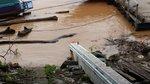
The following taken on 12-Aug-2008

customsroof.jpg


customsrear2.jpg


Hear is the turnoff to Phu Chi Fa leaving Chiang Khong

faturn.jpg


You can check the levels and forecasts on the below websites.

Regional Flood Management and Mitigation Centre

Regional Flood Management and Mitigation Centre

They say the river should be at it’s crest and start to go down at Chiang Khong tomorrow, but Vientiane and Luang Prabang are above flood stage now and still rising. Some GT-Riders are headed that way or in the area now and should be able to provide more info.
 
Dang! You beat me to it. But it's just as well, as yesterday the counter tops were still above the water line.

We went around the northern Mekong loop (off the 1129) and the water was 1m below the road. Seeing that in your later pix the water is up to the roof line I would say that road is now under water.

There is a resort there near the top of the loop and the owner pointed to his meeting room. The roof line was under the water. More bad planning, me thinks...
 
Aug 13, 2008
1
0
0
cheers for the update on the border situation!!!
we actually planned to cross over to laos at this point in about 5 days...
maybe better to wait for a while!

thanks again

darius
 
Mar 15, 2003
1,527
16
38
www.daveearly.com
More>>>

LOEI, Aug 13 -- Heavy rains continued to hit northern and northeastern Thailand on Wednesday, pouring water from many tributaries into the mainstream Mekong River, with the weather department issuing a warning that more rain is on the way due to a low pressure system passing the regions from neighbouring Laos.

The Mekong River early Wednesday overflowed its banks here and in at least two other districts in this northeastern province are now under floodwaters measuring some 50-70 centimetres in depth.

Six houses in a village in Chiang Khan district were destroyed and several roads damaged.

Relief workers helped local residents to move their valuables to higher ground.

The Meteorological Department station in Loei said current heavy rains resulted from a weather system trough of low pressure across northern and northeastern Thailand. Heavy rains will cause the water levels in the Mekong River as well as other rivers to continue rising and people living near the banks should be on alert for flash floods.

In the northernmost province of Chiang Rai, the flooding situation remained critical as the water level in the Mekong River receded only slightly while a section of the road linking Chiang Saen and Chiang Khong districts was still under water over 50 centimetres deep.

A port in Chiang Saen was closed due to the sharp rise of water volume in the river and goods loading or unloading into boats had to be conducted manually by dockside labourers. (TNA)

Mekong water levels flood Nong Khai

The water level of the Mekong river in Nong Khai province this morning exceeded critical height and has begun to pose a threat of flooding. The Hydrology Survey Center of Nong Khai measured water levels at 13.19 meters today, an increase of 34 centimeters from yesterday and the highest recorded level in 42 years, exceeding a previous record flood high of 13.12 meters.

The Department of Water Resources reports that water levels in northern province Loei remain high and will thus contribute to a constant rise to the Mekong further south. Seventeen schools have been shut down following flood situations in 4 districts of northern provinces.

The governor of Nong Khai has ordered the opening of a temporary shelter for those afflicted by the flood.
 
I won't bore you with more pix from the Chiang Khong border, but I do want to share a couple with you from that resort up north. Very nice, lunch by the river, watching things go by. But, before we sat down to lunch I got accosted by this very colourful bug:

IMG_6125.jpg


When it flies it shows very nice blue and white, its body is bright pink. Once it landed on my hand it started poking my skin with its proboscis, seemingly getting high on whatever it found there. Su called me down to the river to show me what happened to the meeting room. The bug stayed put and was quite hard to get to move in the end. Anyway, here is the meeting room:

IMG_6130.jpg


Another bit of bad planning. Judging by Colin's later pix from the border there won't be much of the roof line showing any more now and the road we travelled on must be flooded now, too.
 

DavidFL

0
Staff member
Subscribed
Jan 16, 2003
14,455
5,287
113
70
Chiang Khong
www.thegtrider.com
beddhist wrote: I won't bore you with more pix from the Chiang Khong border, but I do want to share a couple with you from that resort up north. Very nice, lunch by the river, watching things go by.

..................Anyway, here is the meeting room:

IMG_6130.jpg


Another bit of bad planning. Judging by Colin's later pix from the border there won't be much of the roof line showing any more now and the road we travelled on must be flooded now, too.
Beddhist
Is this the Rai Saeng Arun resort you're talking about??
323437201_A2rNd-M.jpg

Mentioned here
https://www.gt-rider.com/thailand-motorc ... t4099.html
 
Yep, the very same one. Sorry, I didn't have your new map at hand when I wrote this, but that's how we found it in the first place. The water level in my picture corresponds with the passport counter at Chiang Khong just above the water line. Which means, judging from the later customs house pix, that the next day the roof would have been almost completely submerged and the road at one point was very likely also (just) under water.
 

Rhodie

0
Mar 5, 2006
842
5
18
An update to David & Mai's as well as Beddhist's remarkable pictures.

Mekong1LR.jpg


Yesterday at Rai Saeung Arun Resort the waters had receded considerably;
but they were clearing up, salvaging what fittings they could - though the silt was deep in parts on the decking.

Mekong2LR.jpg


In spite of their difficulties the charming couple were gracious hosts & served up some of the best chicken & rice we have ever tasted.
The herb & vegetable garden was untouched & accounted for the delicious food.
If you are looking out for a lovely place on the river to chill out you could not get better.
The chalets on stilts were untouched and the service is first class.

MekongPanoLR.jpg


Further south we pulled into Huai Sai Mann viewpoint you can see the reddish brown areas where fields of maze were wiped out by the floods.
I see the press are calling it this the highest the Mekong has been for a century...
LadsViewLR.jpg

Nearby some lads were having a pungent lao-lao sundowner

ChiangKhngLoadingLR.jpg


In Chiang Khong The customs offices have been scrubbed clean & ferry service has been resumed.

Further south the GT Riders' favourite pie stop[Charoen Resort along 118] is as popular as ever.

ValetParkingLR.jpg

Though the Valet Parking still needs to be perfected.
 

erg

0
Aug 19, 2008
1
0
0
Thanks for letting me register on to this side, very nice pics, hope to contribute in the near future.
erwin
 

DavidFL

0
Staff member
Subscribed
Jan 16, 2003
14,455
5,287
113
70
Chiang Khong
www.thegtrider.com
August 2015 - 7 years on from 2008 flood - a view of Rai Saeng Arun from the Lao side.
IMG_9090.jpg
IMG_9091.jpg
 

Attachments

  • IMG_9090.jpg
    IMG_9090.jpg
    126.6 KB · Views: 172
  • IMG_9091.jpg
    IMG_9091.jpg
    125.8 KB · Views: 124
Last edited:

DavidFL

0
Staff member
Subscribed
Jan 16, 2003
14,455
5,287
113
70
Chiang Khong
www.thegtrider.com
2018 and ten years on from the 2008 flood & the Mekong is flooding downstream from Nong Khai.

The 'Khong in Chiang Khong is up, but nowhere near as bad as 2008.

Some pictures from today 30 July 2018.

DSC_0049.JPG


DSC_0050.JPG


DSC_0052.JPG


DSC_0057.JPG


as you can see it still has a way to go, to get to the 2008 flood level.

2008 below

customsroof-jpg.jpg
 
Last edited:

Dodraugen

0
Subscribed
Aug 19, 2012
364
268
63
56
Lampang
But we still have August and September, the heaviest rain months left.... Anyway - cross my fingers for a no repeat of 2008 and 2011.
 

ianyonok

0
Subscribed
Dec 9, 2008
1,082
862
113
Some pics from Chiang Saen, 30th July 2018. 1" of rain the night before.

The Kam river near it's mouth into the Khong, just south of Chiang Saen..
2018-07-30 14.32.52.jpg


The Kok river mouth a bit further to the south.
2018-07-30 14.24.17.jpg


Views from Wat Prathat PaNgow mountain.

The Kam river mouth below.
2018-07-30 14.01.43.jpg


Looking east to the Kok river mouth.
2018-07-30 14.00.57.jpg

Looking west. The island in the river bend off Chiang Saen town, looks a bit smaller....
2018-07-30 14.00.39.jpg

The marker is the T junction at the river in Chiang Saen, During the 2018 flood, We saw 10.5m. Now 6.75m. Low water dry season can be 2m.
2018-07-30 13.26.48.jpg


The pontoons at the town port are coming up to horizontal.
2018-07-30 13.26.10.jpg


06:00 31st July 2018.

Another inch of rain overnight.
The level marker is now at 7.05m, so the river has risen 30cm in 24 hours.
2018-07-31 06.06.35.jpg

Theres was some flotsam and jetsam in the river, yesterday.
But massive amounts of of it today. Tree trunks, branches, bits of houses..... There must be a mountain of debris at the Xayabouri dam.
2018-07-31 05.58.23.jpg
2018-07-31 05.54.07.jpg
2018-07-31 05.53.53.jpg

People will be moving their gangplanks up again this morning
2018-07-31 05.53.18.jpg
 

Attachments

  • 2018-07-30 13.25.02.jpg
    2018-07-30 13.25.02.jpg
    130.3 KB · Views: 185
Last edited:
  • Like
Reactions: Moto-Rex

ianyonok

0
Subscribed
Dec 9, 2008
1,082
862
113
The river does go up and down surprisingly quickly. I had another look 3 hours later this morning and it has risen another 5cm, now at 7.1m.

2018-07-31 09.12.37.jpg
 
  • Like
Reactions: DavidFL

DavidFL

0
Staff member
Subscribed
Jan 16, 2003
14,455
5,287
113
70
Chiang Khong
www.thegtrider.com
Resurrecting an old thread. The Khong is up high again after some torrential rain to the North.

My marker for the Mekong in full flow / flood is the little power box on the main cargo port ramp.
1626974435623.png


1626974447006.png


The water occasionally gets right there, and when it does you know there's a hell of a lot water flowing down the Mekong.
2018 was the most recent big one.

30 July 2018
1626974785202.jpeg


1 August 2018
1626974838415.png


1626974860931.png


6 September 2018
1626974890262.png


The main down town port Chiang Khong - under water.
1626975128587.png


1626975142825.png


The port 7 July 2021
1626975409308.png


22 July 2021 @ the main cargo port.
1626975592911.png