This partly offroad loop should perhaps be called a deteriorating loop. But it depends...
If you are a road rider going north to south, it does deteriorate. But if you want offroad, it deteriorates going south to north...

It is situated to the east of the 1120, between Chiang Muan and Song, in the north of Phrae province.
The Thinknet map shows that the road ends at Bahn Huai Pong.

The turn off the main road looks innocent enough..

There is also a nice new tarmac road surface..

So, the total length of the loop is about 35klms.

The road undulates wonderfully, up hills and down dales.


Looking towards the mountain ridge we have to cross later.

Great riding, zero traffic.

About 2/3 of the way round, the tarmac changes to a narrower concrete road.


Then about 3/4 of the way round the concrete turns to a dirt road..


Then it is farming only. You can see ahead the ridge you have to cross.


Looks pretty easy really...

But it gets steeper. This is looking back down.


Into the good stuff...

But there is more yet..

Another ridge ahead to cross.

At this point the gps shows you are only about 4 klm from getting back on to the main road, 1120.

Great fun here...

The first time I found this loop I was on a road bike and had to stop at about this point. So near yet so far...


Some very steep sections here.


Then finally you come up on to the top of the last ridge and are rewarded with a super view looking down into the valley and the 1120.


Have to be careful on the descent, loose surface and large rocks.

Down into the valley.

A bunch of kids were cooling off in the river.


Out through the village...

..and back onto the 1120.... at Bahn Pa Lao.

A wonderful degenerate loop.
If you are a road rider going north to south, it does deteriorate. But if you want offroad, it deteriorates going south to north...
It is situated to the east of the 1120, between Chiang Muan and Song, in the north of Phrae province.
The Thinknet map shows that the road ends at Bahn Huai Pong.
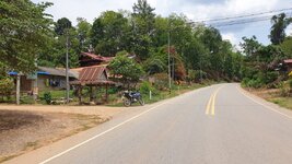
The turn off the main road looks innocent enough..
There is also a nice new tarmac road surface..
So, the total length of the loop is about 35klms.
The road undulates wonderfully, up hills and down dales.
Looking towards the mountain ridge we have to cross later.
Great riding, zero traffic.
About 2/3 of the way round, the tarmac changes to a narrower concrete road.
Then about 3/4 of the way round the concrete turns to a dirt road..
Then it is farming only. You can see ahead the ridge you have to cross.
Looks pretty easy really...
But it gets steeper. This is looking back down.
Into the good stuff...
But there is more yet..
Another ridge ahead to cross.
At this point the gps shows you are only about 4 klm from getting back on to the main road, 1120.
Great fun here...
The first time I found this loop I was on a road bike and had to stop at about this point. So near yet so far...
Some very steep sections here.
Then finally you come up on to the top of the last ridge and are rewarded with a super view looking down into the valley and the 1120.
Have to be careful on the descent, loose surface and large rocks.
Down into the valley.
A bunch of kids were cooling off in the river.
Out through the village...
..and back onto the 1120.... at Bahn Pa Lao.
A wonderful degenerate loop.