North Thailand Top Ten Roads

Dodraugen

0
Subscribed
Aug 19, 2012
364
268
63
56
Lampang
Another suggestion:

Route 3056 from Mae Tuen to Mae Ramat (or opposite of course)
Approx 85 kms of concrete road through extreme scenery. The road snakes through breathtaking landscape and endless extremely steep hills, several inclines more than 30 %! Do have fresh brakepads when going to ride that road!

No R3056 is not even on Google maps but me and a mate rode it a month ago so its certainly there. Just not marked on Google maps with a number….

Ride to the end of R1099 past Omkoi and to Mae Tuen - and turn left and cross the river and you should be near the start of R3056.

We met many thai bikers on this stretch - so this road is obviously well known amongst thais.
Some of the thais we met rode really rare bikes too….


IMG_6809.jpeg

Sign says 28 % incline. There were some signs elsewhere along the road saying more than 30 % incline.

IMG_6889.jpeg

Nice scenery along the road

IMG_6800.jpeg

More nice scenery

IMG_6806.jpeg

Some of the Thai riders we met rode really cool and rare bikes. A Ducati Scrambler from early 70’s I guess?

IMG_6803.jpeg

An old BMW GS airhead


IMG_6804.jpeg

Honda XR250 Baja with double headlights.
 
Last edited by a moderator:

DavidFL

0
Staff member
Subscribed
Jan 16, 2003
14,482
5,315
113
70
Chiang Khong
www.thegtrider.com
Another suggestion:

Route 3056 from Mae Tuen to Mae Ramat (or opposite of course)
Approx 85 kms of concrete road through extreme scenery. The road snakes through breathtaking landscape and endless extremely steep hills, several inclines more than 30 %! Do have fresh brakepads when going to ride that road!

No R3056 is not even on Google maps but me and a mate rode it a month ago so its certainly there. Just not marked on Google maps with a number….

Ride to the end of R1099 past Omkoi and to Mae Tuen - and turn left and cross the river and you should be near the start of R3056.

We met many thai bikers on this stretch - so this road is obviously well known amongst thais.
Some of the thais we met rode really rare bikes too….


View attachment 153342
Sign says 28 % incline. There were some signs elsewhere along the road saying more than 30 % incline.

View attachment 153343
Nice scenery along the road

View attachment 153344
More nice scenery

View attachment 153345
Some of the Thai riders we met rode really cool and rare bikes. A Ducati Scrambler from early 70’s I guess?

View attachment 153346
An old BMW GS airhead


View attachment 153349
Honda XR250 Baja with double headlights.

Thanks for the post. That road has been on my bucket list for a while now, especially as it the new proclaimed steepest road.
 

Moor66

Member
Subscribed
Aug 20, 2023
19
15
3
I just rode that 3054 from Mae Ramat up north. Super nice one!
And have scenic lunch pitstop halfway.
Re the signposted %, sometimes the thai's count both up and down!
The 34% is "only" 17%, but surely super steep by any standards!
IMG_9028.jpeg

Unloaded 2wd pickups without a limited slip rear will struggle on dry asphalt, at a coffeeshop they told me they must to wait for dry tarmac if rainy!

IMG_9032.jpeg
 
Last edited by a moderator:
  • Like
Reactions: Dodraugen

Morningrider

Active Member
Subscribed
May 19, 2023
33
26
18
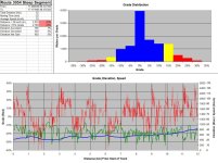
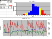
I was curious which was steeper, the west 12 km of the 4009, or the steepest 12 km of the 3054. I used Excel to compare my Garmin GPS tracks of those rides. It was not easy but I have too much time on my hands when I am not riding. It turns out that they both cover about 1% of their distance at over 30% grade—no significant difference at the extreme—but only about 23% of the 3054 steepest segment is covered at over 15% grade, compared to about 31% of the 4009 west segment, so the 4009 is significantly steeper and may well be the steepest 12 km of road in Thailand.

3054.jpg 4009.jpg
I made some other comparisons (percentage distance at over 15% grade, based on Garmin tracks):
Route 4009 West Segment, 12 km: 31%
Elephant Pass to Viewpoint, 24 km: 28%
Route 1345 to Viewpoint, 14 km: 25%
Eng Neo Microwave Road, 7 km: 25%
Route 3054 Steepest Segment, 12 km: 23%
Route 1090 near Umphang, 80 km: 22%
Route 1256 to Doi Phu Kha, 36 km: 19%
Route 1090 Maesot to Umphang, 163 km: 16%
Route 3054 to Mae Tuen, 72 km: 16%
Route 4009 Past Sunflowers, 54 km: 14%
Route 1009 to Doi Inthanon, 39 km: 7%
Route 1148 past Biker Cafe, 61 km: 2%
 
  • Like
Reactions: Moor66

Dodraugen

0
Subscribed
Aug 19, 2012
364
268
63
56
Lampang
Well if you pick the exact steepest stretch of one road and then compare it with the same length on other roads you might get such results. But its not an objective analysis of the whole stretch of different roads if you only compare a little stretch of each road.

The 4009 is also insanely steep for a few kms, absolutely true that.
The R3056 is insanely steep almost all the way of 85 kms, and it is full of hairpins as well. And it is a narrow concrete track as well - all the 85 kms…

But I give you kudos for taking your time doing such an comparement….
 

Morningrider

Active Member
Subscribed
May 19, 2023
33
26
18
The 3054 for the 72 km to Mae Tuen is in the table above, fourth row from the bottom; about 16% of it is over 15% grade, compared to about 14% of the 54 km of the 4009--just slighly more. Both are less than the 80 km of the 1090 to Umphang at 22% and the 24 km to the Elephant pass of 28%.

I was just trying to offer a solution to question of which is the steepest road. Of course with different cutoffs for "steep" you get different rankings. But the surface and narrowness and traffic and the risk if a lorry comes the other way up or down the single-land wide bend and there is nowhere to move over make all these really steep roads dangerous, compared to say the 1090 which is wider. I made an attempt to calculate the tightness of the curves too, but the Garmin trackpoints were not close enough together to do it.
 
  • Like
Reactions: DavidFL

DavidFL

0
Staff member
Subscribed
Jan 16, 2003
14,482
5,315
113
70
Chiang Khong
www.thegtrider.com
I was curious which was steeper, the west 12 km of the 4009, or the steepest 12 km of the 3054. I used Excel to compare my Garmin GPS tracks of those rides. It was not easy but I have too much time on my hands when I am not riding. It turns out that they both cover about 1% of their distance at over 30% grade—no significant difference at the extreme—but only about 23% of the 3054 steepest segment is covered at over 15% grade, compared to about 31% of the 4009 west segment, so the 4009 is significantly steeper and may well be the steepest 12 km of road in Thailand.

View attachment 153458View attachment 153459
I made some other comparisons (percentage distance at over 15% grade, based on Garmin tracks):
Route 4009 West Segment, 12 km: 31%
Elephant Pass to Viewpoint, 24 km: 28%
Route 1345 to Viewpoint, 14 km: 25%
Eng Neo Microwave Road, 7 km: 25%
Route 3054 Steepest Segment, 12 km: 23%
Route 1090 near Umphang, 80 km: 22%
Route 1256 to Doi Phu Kha, 36 km: 19%
Route 1090 Maesot to Umphang, 163 km: 16%
Route 3054 to Mae Tuen, 72 km: 16%
Route 4009 Past Sunflowers, 54 km: 14%
Route 1009 to Doi Inthanon, 39 km: 7%
Route 1148 past Biker Cafe, 61 km: 2%

Excellent info.
You can take a look at this one & add a few bits if you like.

I'd love to see how the big dipper 4018 fits in our data.
 

Dodraugen

0
Subscribed
Aug 19, 2012
364
268
63
56
Lampang
The 3054 for the 72 km to Mae Tuen is in the table above, fourth row from the bottom; about 16% of it is over 15% grade, compared to about 14% of the 54 km of the 4009--just slighly more. Both are less than the 80 km of the 1090 to Umphang at 22% and the 24 km to the Elephant pass of 28%.

I was just trying to offer a solution to question of which is the steepest road. Of course with different cutoffs for "steep" you get different rankings. But the surface and narrowness and traffic and the risk if a lorry comes the other way up or down the single-land wide bend and there is nowhere to move over make all these really steep roads dangerous, compared to say the 1090 which is wider. I made an attempt to calculate the tightness of the curves too, but the Garmin trackpoints were not close enough together to do it.
Something must be a bit off as the R3054 is at least 85 kms and not 72 kms as you claim. I started noticing the kilometer stones at 85 kms left to Mae Ramat, but I think maybe it already was after riding a few kms.
 

Morningrider

Active Member
Subscribed
May 19, 2023
33
26
18
There are two routes between Mae Tuen, the old one, 85 km (I rode it years ago), and the new one, which is 72 km (I rode it in 2022). Putting the coordinates for Mae Tuen and Mae Ramat in Google Maps today, the old 85 km route is shown as the car route and the new 72 km route is shown as the motorcycle route. 85 km and 72 km are both correct, but about half the routes are different. The milestones must refer to the old/car route.
3054.jpg
 

Dodraugen

0
Subscribed
Aug 19, 2012
364
268
63
56
Lampang
There are two routes between Mae Tuen, the old one, 85 km (I rode it years ago), and the new one, which is 72 km (I rode it in 2022). Putting the coordinates for Mae Tuen and Mae Ramat in Google Maps today, the old 85 km route is shown as the car route and the new 72 km route is shown as the motorcycle route. 85 km and 72 km are both correct, but about half the routes are different. The milestones must refer to the old/car route.
View attachment 153478
A bit strange still as R3054 isnt even marked at all on Google maps.
And Im quite sure I rode the R3054 all the way and saw those kilometer stones counting down from 85 kms. Riding from Mae Tuen to Mae Ramat….

Will have to go back and check it again next time Im in Thailand - which unfortunately is 1 year ahead…
 

Morningrider

Active Member
Subscribed
May 19, 2023
33
26
18
Actually, Google Maps shows the 3054 as an unpaved secondary road (which is what it was until it was concreted a couple of years ago), but you have to zoom quite a lot in to see it:
Google Maps Closeup 3054.jpg


I don’t know how to adjust Google Maps for better visibility of the secondary roads. I overlayed Mapsme/OSM with Google Maps and added my Garmin tracks (the thin red line). All three lines match, so no problem with Mapsme. The main reason Mapsme/OSM shows 78 km and not 72 km for the route is because it includes a bit of the 105 at the south end (the flag is south of the junction with the 105):
Overlay.jpg
 

Dodraugen

0
Subscribed
Aug 19, 2012
364
268
63
56
Lampang
What I meant is that R3054 is not marked as what it is on Google maps - the road that starts out from Mae Tuen. No matter how much I tried to zoom in on different stretches of that road Google doesnt have any name or number of that road… so Google maps is not updated on this road at all.

Well I certainly have a mission next time in Thailand…:cool:
 
  • Like
Reactions: Moor66

Moor66

Member
Subscribed
Aug 20, 2023
19
15
3
This was interesting...
If I put Mae Ramat as starting point, that will be downtown about 3 km south of 1175/105 junction. But 3054 starts in Ban Mong Wa, 3 km north of the junction:
IMG_8973.jpeg

And on your map it starts right out at 105??
If I put in Mae Tuen, that point will be first after the 5th bridge, including the new one, if I come from south. So quite a few kilometers up in Tuen.
I am still in the area. Maybe I should ride it again 555


The new bridge
IMG_9037.jpeg