I was curious to see if it was possible to do the famous Mae Hong Son loop without going on the famous 108 or the 1095....
There was also a few "big ticket' items on my adventure bucket list that I wanted to check out.
1. The helicopter along the Thai Myanmar border,
2. The Shan Liberation Army Base at Doi Tai Leng
3. The Elephant trail from Mae Hong Son to Wat Chan (which got the better of me back in the rainy season)
I ran into a few issues on some of this trail before on a big bike so I decided to take no chances and I rented a CRF250L for the job.
I didn't plan out the exact route before hand, but it roughly could be summarized as follows:
Day 1: Chiang Mai - Wiang Haeng - Muang Noi - Helicopter site - PangMaPha
Day 2: Pang MaPha - Lod Cave road - Cross country to the Jabo Road (1226) - Cross country to Baan Pa Daeng - Doi Tai Leng - Cross country to pop out on the 5013 - Mae Hong Son
Day 3: MHS - Mae Surin National Park - Ban Nong Khiao - Wat Chan (and a good few random hill tribe villages in between!)
Day 4: Wat Chan - Mae Na Chon - Baan Mae Hae - Samoeng - Chiang Mai
Having done a bit of online research in the Facebook forums I discovered to my disappointment that the famous Huey helicopter was no longer there. Rather than scratch the item off the list I decided to go check out the site anyway as the ride was supposed to be really nice.
Day 1 - The Helicopter crash site with no helicopter
I departed Chaing Mai in a Haze right out of a scene from holocaust horror movie and my 19 Baht 7/11 mask disintegrated the first time I tried to take it off. Thankfully by the time I got to Wiang Haeng and up into the hills the smog wasn't so bad.
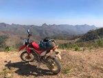
From Wiang Haeng I took the dirt road to Muang Noi then hung right heading north ish towards the Myanmar border. Its a nice ride passing by rice fields and a few small villages before ascending into the mountains. The mountains seem to be a different eco system with pine trees lining the trail. The combination of the shade from the trees and the cooling effect of the increase in altitude made it a very pleasant ride.
View media item 112
View media item 103
Finally I reached the site of the Helicopter crash site with no helicopter. Obviously I was a little disappointed the the online reports of the helicopter being removed turned out to be correct and I missed my opportunity of getting a trophy picture beside the helicopter wreck. However the ride up there was really cool, so still well worth it.
View media item 116View media item 111
The afternoon was closing in so I got going pretty quickly to head down the mountain in the direction of Pang MaPha. The way down was a fair bit more challenging with a few kms being single track over rocks, tree stumps, sand, fallen trees, etc. All good fun though!
As I got closer to Lod Cave area, the views opened up and I was treated to a really cool sunset over some stunning landscape.
View media item 131View media item 136View media item 135View media item 126View media item 110
Spent the night in Pang MaPha
Day 2 Doi Tai Leng - Shan Army Base
I headed back up the same road past Lod Cave except I turned west and headed cross country in the direction of the King Naresuan monument on the border. I popped out on the road to Jabbo. Last year I was stopped by the military on the 1226 north of Jabbo so I decided I needed to find a way around. I found a nice turn off which I guessed would link up with the road to Doi Tai Leng. This turned out to be an epic ride on a mix of concrete and dirt roads through some of the most dramatic mountains and countryside I have ever come across in Thailand.
View media item 104View media item 133
I passed a few military checkpoints on the road to King Naresuan monument and each one just waved me on without me even stopping. When I got near the monument itself the guard even gave me directions!
View media item 137
After checking out the monument and admiring the cool views I genuinely thought that was the end of the line and I would be heading back down. Seeing as I still had lots of time I and I could see on google maps I was inches away from being over the Myanmar border, I though I might as well have a crack and see if I can cross over and get a cool google maps screenshot showing my location over the border. So I headed in the direction of the checkpoint to the army base.
To my amazement the soldier started lifting the barrier before I even got close. Usually I have all my b.s. lines rehearsed in Thai in my head for getting through checkpoints, but on this occasion I didn't want to get in trouble as I was crossing a border. I made the unusual move of stopping and telling the guard I didn't have a passport, visa or anything and was he sure it was ok for me to go there. I wanted to make sure I could still get out! lol. Anyway, sure enough no problemo, so on I went.... into the Shan state.
The Shan flags are very prominent lining the entrance and plenty of military monuments and archways definitely gave me the sense I wasn't really in Thailand any more. It was pretty cool riding around the base pretty much unrestricted. Plenty of other checkpoints just raised the barrier before I even got close and I just cruised on through. I must have rode around the base for about 2-3 hours. It's very extensive, stretching over many hill/mountain tops which are used as lookout points. The ridges linking them have many villages containing housing, shops, schools, restaurants, etc. I was the only Falang in the village and got plenty of surprised looks from the locals. Mind you all of them that I chatted to seemed very friendly even soldiers that were out training.
View media item 115View media item 107View media item 128View media item 125View media item 109
After a few hours I left the base and headed in the direction of Mae Hong Son. I went a different route to that which I came. The route wasn't marked on google maps or maps.me. but I could see I was headed roughly in the correct direction, so I just followed whatever trail was there and sure enough I made it back to MHS before dark. Again, I was treated to some awesome trails and spectacular landscapes along the way. Well worth it.
View media item 132View media item 123View media item 121
All up a very unexpected and cool experience visiting Doi Tai Leng. Well off the beaten track.
Day 3 - MHS to Wat Chan via the elephant trail
The elephant trail had eluded me for quite some time, having got the better of me on two previous occasions. So I was keen to give it another go.
This time it was bone dry, I also had the CRF250L. I just cruised along the trails with zero hassle. There's actually many trails in that region between Mae Surin national park and Wat Chan. I followed most of the trail I didn't do last time but seeing as I had loads of time, I decided to do a bit more exploring around. I'm not 100% sure of my exact route but at one point I popped out at Baan Nong Khiao. I stopped at the OTOP for a bit of lunch. They don't have a restaurant as such but the villagers working there kindly halted their weaving work to make me some noodles. After eating I was back on my way to the trail.
View media item 119View media item 106
The trail was really nice going up and down the hills, past rice terraces, through quaint little Karen villages, with some spectacular views along the way. I arrived in good time to Wat Chan so I drove around a bit trying to check out what accommodation options there were. In fairness there aren't many options but I did find a really nice dinky little home stay. Its basic but new and clean. It's called Rim Tung and it has a great restaurant that overlooks some rice fields. Lovely place for dinner and sunset.
View media item 114View media item 134View media item 130View media item 127View media item 124View media item 122View media item 120
Day 4 - Wat Chan - Mae Na Chon - Chiang Mai
More fantastic trails all the way to Mae Na Chon. Mae Na Chon area itself has a plethora of different trails. Many of the hills nearby have been cleared for agriculture so there's great views for miles around. You can see an endless network of cool trails criss-crossing fields, up and down hills, through forests,etc. I reckon you could stay there for a week exploring around.
Having stopped for an ice cream and a drink, I was back on my way. I wanted to try to get back to Chiang mai off road s much as possible. I followed a dirt road which took me around the north side of Doi Inthanon. There was a fair bit of agriculture going on with some beautiful green irrigated patches in an other wise dry landscape.
View media item 140View media item 139View media item 129View media item 105
All was going well until.....
I don't know how this happened, but going around a corner, my back wheel went out from under me and I went down. I got up right away and hopped back on the bike, only to discover that the damn thing was stuck in 1st gear!
View media item 141
I'm pretty sure, it was a case of the straw that broke the donkey's back and the damage was mostly done before I even rented the bike. Thankfully I was almost at the town of Baan Mae Hae which has a paved road leading to Samoeng. I found a mechanic who said the problem was an internal gear issue and there was no quick fix.
Not that I didn't trust the guy but I decided to cross reference his diagnosis with two other mechanics along the way just to make sure. The bottom line..... I had to knock out the last 80 km back to Chiang Mai in 1st gear! I guess it could have been worse, it could have been stuck in neutral! lol
Summary
Overall it was a really cool 4 day adventure, pretty much in the back yard of Chiang Mai. I only ended up doing about a combined 20 km on the 1095 and 108 just for access to and from MHS. Some of the key highlights being; the helicopter crash site, crossing into Myanmar, Shan army base, cool remote trails, friendly villagers, epic scenery, a few spills and most importantly the epic motorbiking rides to all this stuff. All the makings of a great little adventure.
There was also a few "big ticket' items on my adventure bucket list that I wanted to check out.
1. The helicopter along the Thai Myanmar border,
2. The Shan Liberation Army Base at Doi Tai Leng
3. The Elephant trail from Mae Hong Son to Wat Chan (which got the better of me back in the rainy season)
I ran into a few issues on some of this trail before on a big bike so I decided to take no chances and I rented a CRF250L for the job.
I didn't plan out the exact route before hand, but it roughly could be summarized as follows:
Day 1: Chiang Mai - Wiang Haeng - Muang Noi - Helicopter site - PangMaPha
Day 2: Pang MaPha - Lod Cave road - Cross country to the Jabo Road (1226) - Cross country to Baan Pa Daeng - Doi Tai Leng - Cross country to pop out on the 5013 - Mae Hong Son
Day 3: MHS - Mae Surin National Park - Ban Nong Khiao - Wat Chan (and a good few random hill tribe villages in between!)
Day 4: Wat Chan - Mae Na Chon - Baan Mae Hae - Samoeng - Chiang Mai
Having done a bit of online research in the Facebook forums I discovered to my disappointment that the famous Huey helicopter was no longer there. Rather than scratch the item off the list I decided to go check out the site anyway as the ride was supposed to be really nice.
Day 1 - The Helicopter crash site with no helicopter
I departed Chaing Mai in a Haze right out of a scene from holocaust horror movie and my 19 Baht 7/11 mask disintegrated the first time I tried to take it off. Thankfully by the time I got to Wiang Haeng and up into the hills the smog wasn't so bad.
From Wiang Haeng I took the dirt road to Muang Noi then hung right heading north ish towards the Myanmar border. Its a nice ride passing by rice fields and a few small villages before ascending into the mountains. The mountains seem to be a different eco system with pine trees lining the trail. The combination of the shade from the trees and the cooling effect of the increase in altitude made it a very pleasant ride.
View media item 112
View media item 103
Finally I reached the site of the Helicopter crash site with no helicopter. Obviously I was a little disappointed the the online reports of the helicopter being removed turned out to be correct and I missed my opportunity of getting a trophy picture beside the helicopter wreck. However the ride up there was really cool, so still well worth it.
View media item 116View media item 111
The afternoon was closing in so I got going pretty quickly to head down the mountain in the direction of Pang MaPha. The way down was a fair bit more challenging with a few kms being single track over rocks, tree stumps, sand, fallen trees, etc. All good fun though!
As I got closer to Lod Cave area, the views opened up and I was treated to a really cool sunset over some stunning landscape.
View media item 131View media item 136View media item 135View media item 126View media item 110
Spent the night in Pang MaPha
Day 2 Doi Tai Leng - Shan Army Base
I headed back up the same road past Lod Cave except I turned west and headed cross country in the direction of the King Naresuan monument on the border. I popped out on the road to Jabbo. Last year I was stopped by the military on the 1226 north of Jabbo so I decided I needed to find a way around. I found a nice turn off which I guessed would link up with the road to Doi Tai Leng. This turned out to be an epic ride on a mix of concrete and dirt roads through some of the most dramatic mountains and countryside I have ever come across in Thailand.
View media item 104View media item 133
I passed a few military checkpoints on the road to King Naresuan monument and each one just waved me on without me even stopping. When I got near the monument itself the guard even gave me directions!
View media item 137
After checking out the monument and admiring the cool views I genuinely thought that was the end of the line and I would be heading back down. Seeing as I still had lots of time I and I could see on google maps I was inches away from being over the Myanmar border, I though I might as well have a crack and see if I can cross over and get a cool google maps screenshot showing my location over the border. So I headed in the direction of the checkpoint to the army base.
To my amazement the soldier started lifting the barrier before I even got close. Usually I have all my b.s. lines rehearsed in Thai in my head for getting through checkpoints, but on this occasion I didn't want to get in trouble as I was crossing a border. I made the unusual move of stopping and telling the guard I didn't have a passport, visa or anything and was he sure it was ok for me to go there. I wanted to make sure I could still get out! lol. Anyway, sure enough no problemo, so on I went.... into the Shan state.
The Shan flags are very prominent lining the entrance and plenty of military monuments and archways definitely gave me the sense I wasn't really in Thailand any more. It was pretty cool riding around the base pretty much unrestricted. Plenty of other checkpoints just raised the barrier before I even got close and I just cruised on through. I must have rode around the base for about 2-3 hours. It's very extensive, stretching over many hill/mountain tops which are used as lookout points. The ridges linking them have many villages containing housing, shops, schools, restaurants, etc. I was the only Falang in the village and got plenty of surprised looks from the locals. Mind you all of them that I chatted to seemed very friendly even soldiers that were out training.
View media item 115View media item 107View media item 128View media item 125View media item 109
After a few hours I left the base and headed in the direction of Mae Hong Son. I went a different route to that which I came. The route wasn't marked on google maps or maps.me. but I could see I was headed roughly in the correct direction, so I just followed whatever trail was there and sure enough I made it back to MHS before dark. Again, I was treated to some awesome trails and spectacular landscapes along the way. Well worth it.
View media item 132View media item 123View media item 121
All up a very unexpected and cool experience visiting Doi Tai Leng. Well off the beaten track.
Day 3 - MHS to Wat Chan via the elephant trail
The elephant trail had eluded me for quite some time, having got the better of me on two previous occasions. So I was keen to give it another go.
My first attempt last year was on the Africa Twin. Going in the direction from Wat Chan to MHS. All was going fine until there was a torrential down pour which turned the dirt road into a mud waterfall! Red clay + ruts + steep inclines + torrential rain * (on a heavy bike) = not happening! Cutting a long story short I spent the night in one of the Karen hill tribe villages on the trail. The villagers were super nice insisting that I have dinner with them and stay at their house that night.
View media item 145View media item 142
The villagers were well surprised to see me and pretty much everyone on the village came to the house to say hello to me. This village was so remote that it didn't have any phone signal or proper electricity. They had a few solar panels that they used to save enough power during the day to watch the world cup that evening. There were no other lights other than torches.
View media item 143View media item 144
There must have only been one TV with electricity in the village as everyone came over to watch the world cup. Turned out to be another one of those surprise cool experiences.
The next day the mud was still super slick with steep sections. The villagers helped me by showing me another side trail that took me back to Pai. So, I had to abandon the trail and never made it to MHS.
I didn't get the journey I set out for but I definitely had a far cooler experience")
View media item 145View media item 142
The villagers were well surprised to see me and pretty much everyone on the village came to the house to say hello to me. This village was so remote that it didn't have any phone signal or proper electricity. They had a few solar panels that they used to save enough power during the day to watch the world cup that evening. There were no other lights other than torches.
View media item 143View media item 144
There must have only been one TV with electricity in the village as everyone came over to watch the world cup. Turned out to be another one of those surprise cool experiences.
The next day the mud was still super slick with steep sections. The villagers helped me by showing me another side trail that took me back to Pai. So, I had to abandon the trail and never made it to MHS.
I didn't get the journey I set out for but I definitely had a far cooler experience
This time it was bone dry, I also had the CRF250L. I just cruised along the trails with zero hassle. There's actually many trails in that region between Mae Surin national park and Wat Chan. I followed most of the trail I didn't do last time but seeing as I had loads of time, I decided to do a bit more exploring around. I'm not 100% sure of my exact route but at one point I popped out at Baan Nong Khiao. I stopped at the OTOP for a bit of lunch. They don't have a restaurant as such but the villagers working there kindly halted their weaving work to make me some noodles. After eating I was back on my way to the trail.
View media item 119View media item 106
The trail was really nice going up and down the hills, past rice terraces, through quaint little Karen villages, with some spectacular views along the way. I arrived in good time to Wat Chan so I drove around a bit trying to check out what accommodation options there were. In fairness there aren't many options but I did find a really nice dinky little home stay. Its basic but new and clean. It's called Rim Tung and it has a great restaurant that overlooks some rice fields. Lovely place for dinner and sunset.
View media item 114View media item 134View media item 130View media item 127View media item 124View media item 122View media item 120
Day 4 - Wat Chan - Mae Na Chon - Chiang Mai
More fantastic trails all the way to Mae Na Chon. Mae Na Chon area itself has a plethora of different trails. Many of the hills nearby have been cleared for agriculture so there's great views for miles around. You can see an endless network of cool trails criss-crossing fields, up and down hills, through forests,etc. I reckon you could stay there for a week exploring around.
Having stopped for an ice cream and a drink, I was back on my way. I wanted to try to get back to Chiang mai off road s much as possible. I followed a dirt road which took me around the north side of Doi Inthanon. There was a fair bit of agriculture going on with some beautiful green irrigated patches in an other wise dry landscape.
View media item 140View media item 139View media item 129View media item 105
All was going well until.....
I don't know how this happened, but going around a corner, my back wheel went out from under me and I went down. I got up right away and hopped back on the bike, only to discover that the damn thing was stuck in 1st gear!
View media item 141
I'm pretty sure, it was a case of the straw that broke the donkey's back and the damage was mostly done before I even rented the bike. Thankfully I was almost at the town of Baan Mae Hae which has a paved road leading to Samoeng. I found a mechanic who said the problem was an internal gear issue and there was no quick fix.
Not that I didn't trust the guy but I decided to cross reference his diagnosis with two other mechanics along the way just to make sure. The bottom line..... I had to knock out the last 80 km back to Chiang Mai in 1st gear! I guess it could have been worse, it could have been stuck in neutral! lol
Summary
Overall it was a really cool 4 day adventure, pretty much in the back yard of Chiang Mai. I only ended up doing about a combined 20 km on the 1095 and 108 just for access to and from MHS. Some of the key highlights being; the helicopter crash site, crossing into Myanmar, Shan army base, cool remote trails, friendly villagers, epic scenery, a few spills and most importantly the epic motorbiking rides to all this stuff. All the makings of a great little adventure.