
I thought I'd try some camping again as we are coming to the end of the rainy season.
This was to be a fairly long distance trip, so I packed chain spray & gasket sealant, as well as the full toolkit with spare Boyer ignition control unit and spare clutch cable, plus bulbs and other bits.
Tent & sleeping kit in right pannier, cooking kit & food in the left pannier, with clothes etc in the rear bag.

North of Phrae, I turned off the 103 at Song and cut across west and southwest following the Mae Ta river down to Bahn Nam Rin on the 1023. Along this nice quiet road I came to this


This was clearly an important Seri Thai site from World War II.


The two aircraft were quite good mock-ups and the site is on the rise of a hill, Phae Beang.


Later, I found a little clip on YouTube explaining this site.
The Seri Thai Monument is at; N 18.32158, E 100.09277.
The Seri Thai Cave is close by, near the base of this most prominent small mountain. This would have been an easy to spot landmark for the allied aircraft flying supplies in to the Seri Thai fighters.

The turn-off to the Seri Thai Cave at; N 18.27829, E 100.05747.


2 klms to the Seri Thai cave.
From a visit to the cave itself a couple of years ago;
The Seri Thai Cave and Wat Chalerm Phrakiat Phrachomklao Rajanusorn

The signs tell that it was from here, Pha Bong, that the Seri Thai were in radio comms with the Allies and passing information about the strength and location of the occupying Japanese forces.

It looked like this was an alternative entrance to the Seri Thai Cave. But the gate was padlocked and wrapped with barbed wire. The sign interested me, as it said; No Entry, have "Haw". No-one seems to know what this word means.
Perhaps it means possible unexploded bombs dropped on the Seri Thai by the Japanese or Thai Air Force. Or perhaps it means land mines laid by the Seri Thai to protect their cave and radio station. I climbed the fence and walked in a little way, but decided it may not be safe, so I returned and rode on.
 Pha Bong is a very pointy mountain top.

Continuing down the 1023 to Wang Chin, I got to my destination for the night at the Wiang Kosai National Park.
 I was carrying a large sheet of plastic as somewhere to cook and change if it rained heavily.

Next morning, the waterfalls looked splendid, but everywhere was very wet and slippery after the nights rain. The nature trail to the top of the falls was not passable due to the rain, so that will have to wait for another time.

 Looks like the nature trail goes up 7 cataracts of the falls.

So, I rode on down the 1124 to Thoen and then highway 1 to Tak and Kamphaeng Phet. Turned off down the 1117 west to the Mae Wong NP.
A huge dark cloud was approaching so I pulled into a roadside sala for shelter. Then looked at why the clutch was getting a bit sticky. Aghh.. the clutch cable was about to break 3" up from the operating lever, where it passes through the outer cable holding bracket. Not surprising it was breaking, as the cable is positioned wrong giving a sharp turn at the bracket... something I should have fixed a while ago...
Luckily, I had tools and a spare cable. I bought the original Triumph toolkit Whitworth spanners on ebay, some years ago. The King Dick adjustable spanner is very good. It gives a more solid grip on a nut than a crescent wrench as the top jaw cannot get sloppy, but is harder to use in confined spaces.

The old cable I had fitted at home was galvanised steel and the emergency cable is stainless steel and not as strong, but fine for an emergency. I had soldered the top nipple on at home and then used an emergency locking nipple with the correct trumpet nipple to fit the lever. I had never had to replace a cable on the road before, but this worked well for the rest of the trip.

By the time I had finished fitting the cable, the rain had passed and I rode on. But by now it was really too late to get to the Mae Wong NP HQ and set up camp, so I rolled into a resort in Klong Lan, before the park.
Dinner at a local restaurant

Back at the resort making tea...

The purple box contains the micro cooker,, cooker stand and firesteel. The flatpack silicone sided Sea to Summit X-Pot and X-Cup are great space savers..... Unfortunately, the gas bottle doesn't fit in the purple box....

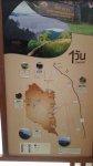
Next morning it's off into Mae Wong NP. This is a huge area of wilderness comprising Mae Wong, Huai Kha Khaeng and Thung Yai Naresuan National Parks. The last great park area in Thailand and contains some spectacular wildlife.


One reason for coming to Mae Wong was to check out the hike to Mount Mokochu.

This is a tough 5 day hike and I was surprised to find out it was a hike of 64 klms.
The contour map at the HQ is interesting. It shows the red string of the road going to right, up to the Chong Yen viewpoint on the Umphang border. The yellow string to the left is the hiking trail, going to Mount Mokochu, also on the border and to three remote waterfalls. They only do the hike with a minimum of 6 people and you can sign up on their FB page.


I'm always impressed at how organised the parks are. This guy had spray painted brown some new steel pipe railings and was now brush painting some black streaks on it, to imitate wood.

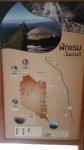
So, the one way road is 28klms to Chong Yen, with rapids and viewpoints on the way.

Due to the rain overnight, the road was wet, slimy and very slippery, so I took it pretty slowly.

It is a wonderful road though, great jungle scenery.

Spectacular views looking west at the Khiew Krathing viewpoint


Then continuing on the road to the end. Past a recent rockfall.

Then arrived at the Chong Yen Viewpoint and the end of the road.

The Ghost road to Umphang. The GPS showed the road going about another 12klms. But soon after this gateway, the side of the tarmac road has slipped down into the valley. This is a hiking trail only now, but at this time of year, lots of leeches around.

There are also Blackflies here and I got some bites which were extremely itchy and caused lumps that lasted for several days.


I made some coffee and sandwiches while waiting for some old friends to roll up. I hadn't seen Gary Sharpeyes for several years and he was riding up from Pattaya with Patrice and Rob from Nakhon Phanom.

So, we all rode back down the 1117 and then across rural roads to Tak. I checked into the Tak Andaman Resort, as by this time, I had come to the conclusion, it wasn't really camping weather at this time.......!
But also, the National Park nature trails are yet to be cleared for the cool season... and then there are the leeches....
In the hotel, there was perhaps the largest single piece of wood table, I have ever seen. It was about 1.5m wide and 3.5m long....... no more trees that big anymore..

Next day, I decided I would ride all the way home up highway 1.
A stop in Lampang at Wat Prathat Lampang Luang, that I hadn't visited for about 20 years. Still a lovely old temple.


I had forgotten there were some nice murals on the wooden sideboards of the viharn.


There was one of these characters outside each corner of the large brass covered stupa.

I also stopped in Pratu Pha, the gap in the stone curtain, halfway between Lampang and Ngao. A spot I've always though very special.
I had to go and have a look at the prehistoric cave art there as well. Something that perhaps few people take the time to check out. It is easy to visit and the paved walk along the edge of the rock face goes to the south about 1 klm.


Huge stalactites above your head are a bit off-putting.....


I cruised back up highway 1 at around 60mph and covered 300 miles in a day. Total 900 miles in 4 days. The bike performed faultlessly, apart from the clutch cable, which was my fault. But I'll need to wash the oil off the engine as some of the gaskets are getting a bit leaky........

This was to be a fairly long distance trip, so I packed chain spray & gasket sealant, as well as the full toolkit with spare Boyer ignition control unit and spare clutch cable, plus bulbs and other bits.
Tent & sleeping kit in right pannier, cooking kit & food in the left pannier, with clothes etc in the rear bag.
North of Phrae, I turned off the 103 at Song and cut across west and southwest following the Mae Ta river down to Bahn Nam Rin on the 1023. Along this nice quiet road I came to this
This was clearly an important Seri Thai site from World War II.
The two aircraft were quite good mock-ups and the site is on the rise of a hill, Phae Beang.
Later, I found a little clip on YouTube explaining this site.
The Seri Thai Monument is at; N 18.32158, E 100.09277.
The Seri Thai Cave is close by, near the base of this most prominent small mountain. This would have been an easy to spot landmark for the allied aircraft flying supplies in to the Seri Thai fighters.
The turn-off to the Seri Thai Cave at; N 18.27829, E 100.05747.
2 klms to the Seri Thai cave.
From a visit to the cave itself a couple of years ago;
The Seri Thai Cave and Wat Chalerm Phrakiat Phrachomklao Rajanusorn
The signs tell that it was from here, Pha Bong, that the Seri Thai were in radio comms with the Allies and passing information about the strength and location of the occupying Japanese forces.
It looked like this was an alternative entrance to the Seri Thai Cave. But the gate was padlocked and wrapped with barbed wire. The sign interested me, as it said; No Entry, have "Haw". No-one seems to know what this word means.
Perhaps it means possible unexploded bombs dropped on the Seri Thai by the Japanese or Thai Air Force. Or perhaps it means land mines laid by the Seri Thai to protect their cave and radio station. I climbed the fence and walked in a little way, but decided it may not be safe, so I returned and rode on.
Continuing down the 1023 to Wang Chin, I got to my destination for the night at the Wiang Kosai National Park.
Next morning, the waterfalls looked splendid, but everywhere was very wet and slippery after the nights rain. The nature trail to the top of the falls was not passable due to the rain, so that will have to wait for another time.
So, I rode on down the 1124 to Thoen and then highway 1 to Tak and Kamphaeng Phet. Turned off down the 1117 west to the Mae Wong NP.
A huge dark cloud was approaching so I pulled into a roadside sala for shelter. Then looked at why the clutch was getting a bit sticky. Aghh.. the clutch cable was about to break 3" up from the operating lever, where it passes through the outer cable holding bracket. Not surprising it was breaking, as the cable is positioned wrong giving a sharp turn at the bracket... something I should have fixed a while ago...
Luckily, I had tools and a spare cable. I bought the original Triumph toolkit Whitworth spanners on ebay, some years ago. The King Dick adjustable spanner is very good. It gives a more solid grip on a nut than a crescent wrench as the top jaw cannot get sloppy, but is harder to use in confined spaces.
The old cable I had fitted at home was galvanised steel and the emergency cable is stainless steel and not as strong, but fine for an emergency. I had soldered the top nipple on at home and then used an emergency locking nipple with the correct trumpet nipple to fit the lever. I had never had to replace a cable on the road before, but this worked well for the rest of the trip.
By the time I had finished fitting the cable, the rain had passed and I rode on. But by now it was really too late to get to the Mae Wong NP HQ and set up camp, so I rolled into a resort in Klong Lan, before the park.
Dinner at a local restaurant
Back at the resort making tea...
The purple box contains the micro cooker,, cooker stand and firesteel. The flatpack silicone sided Sea to Summit X-Pot and X-Cup are great space savers..... Unfortunately, the gas bottle doesn't fit in the purple box....
Next morning it's off into Mae Wong NP. This is a huge area of wilderness comprising Mae Wong, Huai Kha Khaeng and Thung Yai Naresuan National Parks. The last great park area in Thailand and contains some spectacular wildlife.
One reason for coming to Mae Wong was to check out the hike to Mount Mokochu.
This is a tough 5 day hike and I was surprised to find out it was a hike of 64 klms.
The contour map at the HQ is interesting. It shows the red string of the road going to right, up to the Chong Yen viewpoint on the Umphang border. The yellow string to the left is the hiking trail, going to Mount Mokochu, also on the border and to three remote waterfalls. They only do the hike with a minimum of 6 people and you can sign up on their FB page.
I'm always impressed at how organised the parks are. This guy had spray painted brown some new steel pipe railings and was now brush painting some black streaks on it, to imitate wood.
So, the one way road is 28klms to Chong Yen, with rapids and viewpoints on the way.
Due to the rain overnight, the road was wet, slimy and very slippery, so I took it pretty slowly.
It is a wonderful road though, great jungle scenery.
Spectacular views looking west at the Khiew Krathing viewpoint
Then continuing on the road to the end. Past a recent rockfall.
Then arrived at the Chong Yen Viewpoint and the end of the road.
The Ghost road to Umphang. The GPS showed the road going about another 12klms. But soon after this gateway, the side of the tarmac road has slipped down into the valley. This is a hiking trail only now, but at this time of year, lots of leeches around.
There are also Blackflies here and I got some bites which were extremely itchy and caused lumps that lasted for several days.
I made some coffee and sandwiches while waiting for some old friends to roll up. I hadn't seen Gary Sharpeyes for several years and he was riding up from Pattaya with Patrice and Rob from Nakhon Phanom.
So, we all rode back down the 1117 and then across rural roads to Tak. I checked into the Tak Andaman Resort, as by this time, I had come to the conclusion, it wasn't really camping weather at this time.......!
But also, the National Park nature trails are yet to be cleared for the cool season... and then there are the leeches....
In the hotel, there was perhaps the largest single piece of wood table, I have ever seen. It was about 1.5m wide and 3.5m long....... no more trees that big anymore..
Next day, I decided I would ride all the way home up highway 1.
A stop in Lampang at Wat Prathat Lampang Luang, that I hadn't visited for about 20 years. Still a lovely old temple.
I had forgotten there were some nice murals on the wooden sideboards of the viharn.
There was one of these characters outside each corner of the large brass covered stupa.
I also stopped in Pratu Pha, the gap in the stone curtain, halfway between Lampang and Ngao. A spot I've always though very special.
I had to go and have a look at the prehistoric cave art there as well. Something that perhaps few people take the time to check out. It is easy to visit and the paved walk along the edge of the rock face goes to the south about 1 klm.
Huge stalactites above your head are a bit off-putting.....
I cruised back up highway 1 at around 60mph and covered 300 miles in a day. Total 900 miles in 4 days. The bike performed faultlessly, apart from the clutch cable, which was my fault. But I'll need to wash the oil off the engine as some of the gaskets are getting a bit leaky........
Attachments
Last edited:

")