A quick update on the Elephant Trail that runs between Samoeng and Mae Hong Son.

Moto-Rex

0
Subscribed
Jan 5, 2008
961
337
63
A quick update on the Elephant Trail that runs between Samoeng and Mae Hong Son.

The tarmac surface from Samoeng to Wat Chan is in good condition, with most sections that were breaking up with big sharp edged potholes being resurfaced. There’s still about 12kms of dirt south of Wat Chan, but there working on that section now, and it shouldn’t be to long before its tarmac all the way to Wat Chan. There’s really only a 300 metre section that would be difficult on a road bike.

Once it’s finished, it should be a good road ride from Chiang Mai to Pai.

Fortunately, for us dirt riders, the track from Wat Chan to Mae Hong Son is still pretty much the same as it was 5 years ago. And apart from a few concrete sections, its dirt all the way, and in my opinion one of the best rides in Thailand.

This is the dirt track from Wat Chan to Mae Hong Son.
MaeHongSon1.jpg


Its 77km and takes around 2 hours 40 mins when its dry…when it’s wet it could take 2 or 3 times longer.

The same with the vertical profile, Wat Chan to Mae Hong Son. I didn’t bother with the Tar road.
MHS2.jpg


It was the first trip for the new KLX, and it was a good feeling being back on the road.
MHS3.jpg


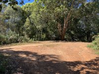
After a pit stop at Wat Chan, it was time to get a bit of red dirt on the new green machine.
MHS4.jpg


It really is a great ride, nothing difficult, shade from the trees all the way, and hardly another person to be seen.
MHS5.jpg


MHS6.jpg


MHS7.jpg


MHS8.jpg


MHS9.jpg


Cool ride.
MHS10.jpg


I did this ride late December 2014

Moto-Rex
 
  • Like
Reactions: Ughetto
Sep 19, 2006
2,393
374
83
62
www.chiangmai-xcentre.com
I agree a Great Ride through there! Very Scenic. Not sure how much longer as I have seen how much more land has been Cleared by HillTribe Squatters! When I first went through there was a lot of Jungle and the Track was Overgrown and fairly Narrow! There is a lot less Jungle now and the Road has widened Considerably!
 

Johpa

0
Aug 22, 2005
85
16
8
Given that you would be hard pressed to find an ethnic Thai between Wat Chan and the Fern Resort, it is rather problematic as to who are the squatters. But still the road remains one of the great dirt rides of the north, for at least a few more years as even the now paved road by my house was once a narrow technical dirt track under the canopy. Once they finish the paving from Samoeng to Wat Chan I believe they will focus on paving the elephant trail to MHS. And then the Bangkok folks will show up with title deeds to land that currently have no titles, the modern Thai version of squatting.
 
Sep 19, 2006
2,393
374
83
62
www.chiangmai-xcentre.com
Love Your Explanation Randy! I think they will have to Fix the Stretch from Wat Chan to Pai first before they head to MHS! On the Squatting Deal, Normal Process is the Government give Title to the Hill Tribe, Thai Yai or Who ever is Squatting at the Present Time! Of Course they Immediately Sell it to the People from Bangkok or who ever has Money actually? Then they move on to another bit of non titled land and start the Process all over again whilst complaining of Persecution and Racism? Lets not forget they Don't Pay any Taxes and get Aid for most things? And Don't mention the Drugs Trade!
Anyway back on Subject it is also a Nice Ride to Khun Yuam from What Chan!
 

Oddvar

0
Subscribed
Mar 18, 2013
534
358
63
Thanks for sharing.
I will agree that the Elephant trail is one of the better rides in the North. But once in Wat Chan, there is a multiple choice of trails leading in all directions.

Elephant%20trail%20to%20MHS.jpg
 

DavidFL

0
Staff member
Subscribed
Jan 16, 2003
14,455
5,287
113
70
Chiang Khong
www.thegtrider.com
fdale;303931 wrote: Is the route clearly marked ? Or is it well travelled so the opportunity to make a wrong turn minimized ?
Should be no trouble. Its clearly marked on the GTR MHS Loop map.
Loads of village names & kms to help guide you along the way.
 

DavidFL

0
Staff member
Subscribed
Jan 16, 2003
14,455
5,287
113
70
Chiang Khong
www.thegtrider.com
I've been sitting on this pic for awhile. Its supposed to be a road in MHS that I'm not sure about, but I've been told it is the "Huai Pu Ling road," MHs - Wat Chan; however I'm not convinced. What do you guys say now - yes or no?


Is his the ascent / descent from just after Fern Resort or....?
 

Guzzibs

Ol'Timer
Subscribed
Jul 20, 2018
46
39
18
Gday guys an update on the road/track from Mae Hon Son through to Wat Chan. I rode it today on the way home from the monthly catch up in Tak on the Rally Raid CB500X for those who were not at the meet and dont know me. Tyres used are Mitas 50/50 Dakars to give some idea of the equipment.
Starting from the Mae Hon Son end as I did is the steepest climb and fall. Climb not too bad on concrete good condition. Coming down the other side was greasy clay even at this dry time. Road at this point/section under construction to concrete.
After this its nearly all bald rocks and rutty shifting gravel especially bad after Huai Poo Ling till you get just south of Huai Tong where the road improves.
My advice for what its worth dont take a road bike it would be very hard work. Plenty of sump breakers and decaying concrete pads and steel mesh to stake a tyre on. Mostly first and second gear work for me with a bit of paddling on some muddy sections.
The signage is great if you can read Thai otherwise a bit scarce. I navigated ok with my sketchy Thai and the locals and the GT rider map.
The upside is some great scenery and spectacular views well worth the trip for me.
So to sum up the road is rough and you should be confident with shifty rocks ,ruts, steep up and downs and have a map. Some sections dont look like they have seen a grader/dozer for quite a while.
Took me about 4.5 hrs to get through.
Give it a go well worth it.
 

Kiwi Cruiser

Ben Kemp
Staff member
May 26, 2007
260
83
28
Thailand
Thanks for the update Brian. Its ages since I was up there, last time was about 4 years ago in the Hilux Sportrider 4WD and it was pretty gnarly getting up the hill, even with the diff locks engaged. It was about the end of Wet Season, and I could not get all the way though to Wat Chan due to inches of wet clay on a section of road works in a gully. Got down the hill into the bottom of the gully, could not get up the other side! :scream:

Managed to turn around with some difficulty, and had a real challenge getting back out to terra firma, mud-grip tyres and all. There were rooster-tails of flying mud to clear the treads, and the truck was covered in it by the time I got back onto "solid" ground.
 
  • Like
Reactions: Ian Bungy

DavidFL

0
Staff member
Subscribed
Jan 16, 2003
14,455
5,287
113
70
Chiang Khong
www.thegtrider.com
Gday guys an update on the road/track from Mae Hon Son through to Wat Chan. I rode it today on the way home from the monthly catch up in Tak on the Rally Raid CB500X for those who were not at the meet and dont know me. Tyres used are Mitas 50/50 Dakars to give some idea of the equipment.
Starting from the Mae Hon Son end as I did is the steepest climb and fall. Climb not too bad on concrete good condition. Coming down the other side was greasy clay even at this dry time. Road at this point/section under construction to concrete.
After this its nearly all bald rocks and rutty shifting gravel especially bad after Huai Poo Ling till you get just south of Huai Tong where the road improves.
My advice for what its worth dont take a road bike it would be very hard work. Plenty of sump breakers and decaying concrete pads and steel mesh to stake a tyre on. Mostly first and second gear work for me with a bit of paddling on some muddy sections.
The signage is great if you can read Thai otherwise a bit scarce. I navigated ok with my sketchy Thai and the locals and the GT rider map.
The upside is some great scenery and spectacular views well worth the trip for me.
So to sum up the road is rough and you should be confident with shifty rocks ,ruts, steep up and downs and have a map. Some sections dont look like they have seen a grader/dozer for quite a while.
Took me about 4.5 hrs to get through.
Give it a go well worth it.

Great update, many thanks Brian. Glad it all worked out ok for you.
Which direction do you think is the
1. Better ride
2. Easier ride

If you have any piccies, you can send them to me with captions & I will upload them for you.
 
  • Like
Reactions: Ian Bungy

Moor66

Member
Subscribed
Aug 20, 2023
19
15
3
Today I rode from Pai to MHS via the western stretch of this route. I don't have a gps (only my phone) and in this remote area no signal for the most part of the ride. I did study maps as usual before, and made notes, but not good enough- more about that later in another thread.

Start via the lovely old Wat Chan 4013 road from Pai
IMG_9357.jpeg


On the way down to the junction (about 65 km from Pai) where I join into the elephant trail. From after ca 35 km mostly gravel and dirt, dusty and bumpy but not that bad.
A few hairpins with 2-3 cm bull dust. Some concreted sections.
Here some road works about to be finished
IMG_9363.jpeg


No need to try to decipher the beautiful old style thai fonts
IMG_9368.jpeg


Thumping along
IMG_9369.jpeg


Finally after 65 km I can choose left to Wat Chan, or right towards 108 just south of MHS town
IMG_9378.jpeg


Now a little bit rough
IMG_9387.jpeg


But soon nicer again
IMG_9399.jpeg


Recently finished and widened concrete road
IMG_9401.jpeg


From junction and west to 108 about 50 km, exit thru Mae Surin national park. Most of those 50 km very steep up and down, again and again, hairpin after hairpin. Suuuper nice road section!
IMG_9405.jpeg


Just a few of the bends
IMG_0390.png
 

Attachments

  • IMG_9378.jpeg
    IMG_9378.jpeg
    442.7 KB · Views: 12