
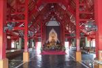
Thailand has more than forty thousand temples [1], most of them gulden and colorfully decorated serve as parish assembly point for all type of cultural and religious activities. The most prestigious constructions often have a royal status or are particularly venerated for their relics or a powerful master's fame; they might be compared with western cathedrals [2]. In some cases, the temple's features, it's situation or design, popularize it as a tourist attraction, not only for Thai devotees, but also for foreign visitors. This is, for instance , the case of " Wat Phra Bat Pupha Dang "located in the Chae Hom district of Lampang province, in Northern Thailand.

To visit this mountain temple, it is possible to follow several itineraries. Starting from Chiangmai , the loop through Mae Kachan, on Route 118, or the trip through Lampang are similar, in road conditions and distances. Other possibilities are to leave Route 118 in Pang Faen and to climb Route 1252 over the mountain, through the Jaeson national park, or to drive from the East, coming from Payao. For all these trips it is advisable to start very early or to spend a night close to Chae Hom, as climbing to the temple becomes arduous once the sun reaches the Northwest hill’s side.
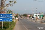
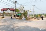
My journey, for this story, starts at the Mae Kachan’s intersection with Route 120, a southern branch out from Route 118, after the city center, at about one hour drive from Chiangmai.

Route 118 and 120 intersection, monument with Royal portraits.
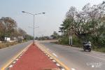
Route 120 is a lovely trail, gently twisting up and downhills to Wiang Nuea, just fifteen kilometers away. At this city’s entrance, large signboards point to Chae Son National Park and to Route 1035, the road to Chae Hom (at 54 kilometers) and Lampang (at 108 kilometers).

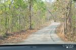
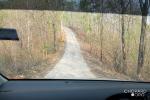
The journeys follows Route 1035, a nice drive but mostly flat and uneventfull.

Passing the middle point of the trip to Chae Hom.
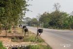
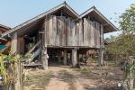
There is always something to wonder about along any itinerary and, on this road, it is worth to have a glance at the many wooden houses, old or new, who are still frequent. The region gives the impression to still be rich in timber as, in other regions, such constructions are nowadays less usual.

This house is for sell – the wood only – at a price of 500’000 THB (US 15’000 $)

A newly built wooden house
Another peculiarity, along Route 1035, are the surelevated trash bins wich, regularly, punctuate the itinerary, denoting environmental awareness or, at least, the availability of a working public trash-collection system.

Ubiquitous surelevated trash bins
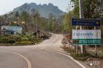
Just before Chae Hom, a bifurcation leads to a city ringroag, in direction of Lampang; this is the itinerary to follow (staying on Route 1035). The branchout to the temple is not far away, a small intersection, slightly hidden, and better visible when coming from the Lampang’s direction.

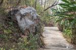
After a short drive, the secondary road leads to the temple’s coumpound

The intersection before Chae Hom leading to the ring road

Following the secondary road for a couple of kilometers.
Driving uphill, the country road leads to the coupound’s “base station”, just after an intersection with a signboard prohibiting all types of vehicles to climb further north.

A narrow trail – closed to the public traffic – leads uphill to the temple.
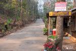
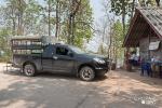
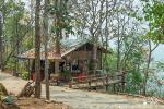
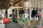
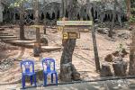
Parking places are available as well as a couple of restaurants and a booth selling tickets (100 THB per pax) for a return ride to the next step, the walking escalade’s departure.
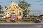
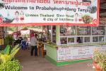
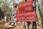
“Welcome to Prabahphuphadand Temple”.
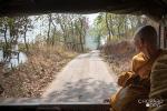
The vehicles have to remain at the “base station” while the passengers – after buying a ticket – can board the official four-wheel drive trucks who, in packs and alternance, climb uphill.

The “base station” ticket booth
The mountain road is steep and narrow, crossing is impossible and non experienced drivers would be challenged to ascend this trail, even without oncoming traffic. The official truck flow is managed through a radio connection, ensuring that the vehicles are only driving in one direction. The schedule is drivren by the passengers’ number and, on days of high affluence, more pick-ups are grouped in a pack.

Steep and narrow road

A nice promenade through the forest

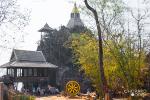
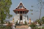
At the upper end station, vehicles turn around, waiting for passengers bound for their downhill journey. Visitors have now the choice to only ramble through the “base station” temple’s coumpound or to climb their way up to the “usual” final destination, the peak stupas.

The first stretch is a 300 meters flat and paved road. Before departure, a small kiosk is the last chance to buy some drinks, and lavatories are also available nearby; nothing – organized – is available uphill.

For the journey’s beginning, the trail is a flat and gentle, three hundred meters, inviting walk.

The “last chance” small coffee shop

Light snacks and drinks are available at the coffee shop, on the “escalade’s” beginning.
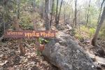
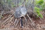
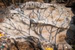
Along the road, big gravity driven boulders are symbolically supported by chimerix bamboo sticks; “no merit is too small for a right cause”.

Boulders sustained by small sticks

A “giant spyder”, a boulder supported by frail bamboo sticks
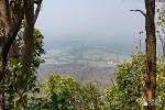
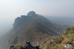
Before climbing to the top, an opening in the forest wall allows to glance to the North, toward the city of Pan (Muang Pan), clouded with smog during this time of the year (March). The most attractive period visit the temple is between November and January, at the end of the rainy season, and before north Thailand’s smoky season.

View toward Muang Pan in the valley
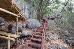
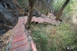
This was the journey’s easy part; the trip becomes now a real “escalade”, even so, the climb is on a concrete footway, with iron stairs.

“Putho Putho” – a small board and a bouder at the path’s beginning

Beginning of a slow ascension on concrete and iron stairs

Some places were hit by flames, but these blazes are limited to accidental fires.
A first bamboo hut provides a rest and shelter after seventy stairs, a great beginning, but there are many more steps to count before reaching the top .

First bamboo restplace
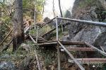
At the slow pace of mountain climbers, step by step, the journey follows the concrete and iron stairs path.

Iron steps all along the hillside.

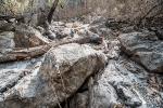
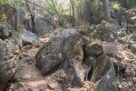
Some stretches are just on dirt ground, passing through boulder walls.

Bamboo stairrails help to secure the way
A second resting place, after one hundred fourty stairs, a last one, at three hundred twenty and, finally, after climbing three hundred sixty stairs, and a number of concrete slopes, the southern morning light illuminates the arrival glade.
It was nine thirty, still relatively early in the morning and on a normal week day. I was alone during the whole escalade but met one family on the top, already on their way back. During the peak season, and on public holidays, the place can, however, be crowded.

The morning sun at the arrival glade

In the Winter season, the vegetation in sparse

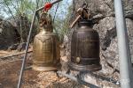
Time to ring a bell to make the Gods aware of our efforts.

Clearly marked boards (for people with a Thai guide) – “the way to the place to pay respect and meditate” and, underneath, a board asking to take the waste back downhill.

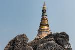
Side of “kot pun punyo nuson” chedi (with its nameboard)
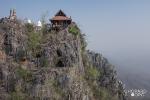
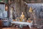
The uphill glade is another “plateform” to visit the skyward temple structures. Stairs and concrete slopes, again, lead to various worshipping places.

A large upper chedi
The southern panorama is gorgeous during the clear sky season; sometimes it is blanqueted by a morning sea of fog, contrasting with a dark blue sky and illuminated by the warm morning light. In the « burning season », however, one can just lament about the region’s bad habit to clean forest and fields by putting them on fire; the view is blurred by smoke.

During the month of March, smoke blurres the valley view
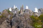
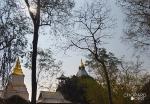
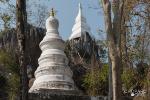
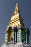
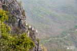
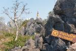
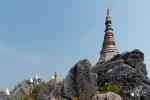
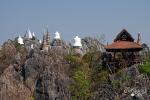
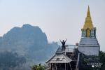
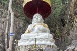
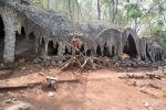
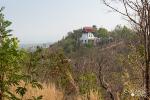
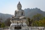
The highlight of Phra Bat Pupha Dang temple is, arguably, its amazing arrangement of chedis coronning ragged boulder peaks. Grey and gulden or white, they integrate man’s devotion symbols with pristine and rugged nature. This construction is the brainchild of Phra Kru Phaiboon [3] a venerable monk. He is the abot of Wat Analayo, a beautiful temple near Payao and has recently supervised “Sam Naksang Thep Nimitr’s” construction, a hillside temple and meditation place, just outside Chiang Khong, behind “Naka’s Kiosken” cafe. This new travel destination, eagle nested and with a georgous view over the Mekong river is another enticement for a visit to that region.

Some chedis are built on unreachable peaks

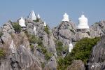
Gulden, grey or white, the chedi contrast with ragged boulder peaks.

White chedis

White chedis on grey boulders

Skyward view, white chedis and blue sky
From the uphill glade “base station”, stairs lead to the main uphill chedi, on one side and two other trails lead to a small temple and a meditation platform on the other side.

Rocks are inviting steps for adventurous climbers, but such perilous enterprises are prohibited.

A “protected” (ordained) tree along the way up to the meditation platform

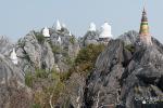
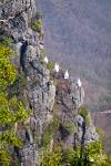
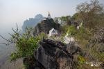
The chedi arrangement on the East side is impressive

Perched on rugged boulders, the chedis are to be admired from afar.

White and colored chedis on the east side

A pattern of wide chedis against their blue sky backdrop

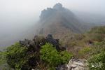
Some chedis were installed downward, along a vertiginous ridge

Downward chedis and panoramic valley view

The main chedi and the backdrop landscape seen from the the opposite viewpoint and meditation plateform

Another view of the main chedi from the opposite viewpoint

In the “burning season”, the view toward the valley is blurred by smog

What could be a georgeous valley panorama is just a dull sight in the wrong season (February to April)

A view point and meditation hall, next to the western side chedis

Watching from one view point to the other – the perched meditation hall and the western side chedis.
After visiting the meditation platform and viewpoint, the journey goes backward, downhill again. Descending the same abrupt iron steps and steep concrete slopes seems, comparatively to the upside escalade, a relative breeze, an easy stroll.

Hiking downward the steep iron steps
The “base station”, the transportation terminus, features several places of interest wich are worth visiting.

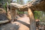
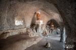
A natural cave is located right behind the arrival parking

Pecular formation of a natural cave

The natural cave is host to some Buddha images

Monks visiting the natural cave featuring Buddha images
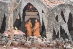
Another point of interest is Buddha footprint temple. A short stroll leads to this place, located slighty downside from the arrival parking.

A short trail leads to the Buddha footprint temple

The worshipping place near the Buddha footprint is a small wooden plateform

There are, actually, two types of rock imprints at this location. One is shaped like a hand, the other one like a foot. These legendary symbols are of course oversized and part of the local Buddhist mythology; they are respected and venerated as religious images. It is not advisable to put one’s foot it these hollows to compare sizes. A Thai TV presenter learned this the hard way; after such an offense, the local community required broadcasted excuses for the disrespectful act. On the marketing side, however, it was a boost for the temple and the foot print became widely known as an place of veneration and worshipping.

Imprint of Lord Buddha’s foot

Phra Sankadjai a Lord Buddha’s disciple
The coumpound features other Buddhist panteon’s images, for instance a statue of Phra Sankadjai, invariably confounded with the “Laughing Budha” as both have bulky representations. More about this in my GT-Rider write up about “The quest for the laughing Buddha”:
North Thailand - 1 The quest for the Lauging Buddha
After riding down to the base station, on a provided “four wheel” transportation, there are some more Buddha images and temples available for a visit.


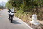
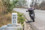
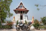
A last motorcycle selfie before the return journey
The complete loop to the temple’s « base station » and back to Mae Kachan’s Route 118 intersection, added one hundred fourthy five kilometers to my odometer, and a couple of thouthand walking steps, some up and down a steep trail. Globally, it is a very enjoyable excurssion worth to be scheduled during the Tai winter, after the rainy season and before the «cleaning » fires’ blurr the landscape uder their smoke.
--------------------------------
Notes:
[1]List of Buddhist temples in Thailand - Wikipedia, the free encyclopedia
[2] The original meaning of cathedral points to an important hierarchical position; this was signaled by a usually more impressive architecture and construction than normal churches. Colloquially the term is used for large and grandiose buildings. In Thailand, the royal temples are usually the most prestigious, however private initative buildings might sometimes acquire a fame for their extraordinary architectures or through the repution of a famous monk
[3] About wat Analayo, see the information in GT-Rider. Luang Po Pai Boon - also patronized the new temple and viewpoint up-hill from Naka Kiosken, near Chiang Khong:
Wat Analayo
To visit this mountain temple, it is possible to follow several itineraries. Starting from Chiangmai , the loop through Mae Kachan, on Route 118, or the trip through Lampang are similar, in road conditions and distances. Other possibilities are to leave Route 118 in Pang Faen and to climb Route 1252 over the mountain, through the Jaeson national park, or to drive from the East, coming from Payao. For all these trips it is advisable to start very early or to spend a night close to Chae Hom, as climbing to the temple becomes arduous once the sun reaches the Northwest hill’s side.
My journey, for this story, starts at the Mae Kachan’s intersection with Route 120, a southern branch out from Route 118, after the city center, at about one hour drive from Chiangmai.
Route 118 and 120 intersection, monument with Royal portraits.
Route 120 is a lovely trail, gently twisting up and downhills to Wiang Nuea, just fifteen kilometers away. At this city’s entrance, large signboards point to Chae Son National Park and to Route 1035, the road to Chae Hom (at 54 kilometers) and Lampang (at 108 kilometers).
The journeys follows Route 1035, a nice drive but mostly flat and uneventfull.
Passing the middle point of the trip to Chae Hom.
There is always something to wonder about along any itinerary and, on this road, it is worth to have a glance at the many wooden houses, old or new, who are still frequent. The region gives the impression to still be rich in timber as, in other regions, such constructions are nowadays less usual.
This house is for sell – the wood only – at a price of 500’000 THB (US 15’000 $)
A newly built wooden house
Another peculiarity, along Route 1035, are the surelevated trash bins wich, regularly, punctuate the itinerary, denoting environmental awareness or, at least, the availability of a working public trash-collection system.
Ubiquitous surelevated trash bins
Just before Chae Hom, a bifurcation leads to a city ringroag, in direction of Lampang; this is the itinerary to follow (staying on Route 1035). The branchout to the temple is not far away, a small intersection, slightly hidden, and better visible when coming from the Lampang’s direction.
After a short drive, the secondary road leads to the temple’s coumpound
The intersection before Chae Hom leading to the ring road
Following the secondary road for a couple of kilometers.
Driving uphill, the country road leads to the coupound’s “base station”, just after an intersection with a signboard prohibiting all types of vehicles to climb further north.
A narrow trail – closed to the public traffic – leads uphill to the temple.
Parking places are available as well as a couple of restaurants and a booth selling tickets (100 THB per pax) for a return ride to the next step, the walking escalade’s departure.
“Welcome to Prabahphuphadand Temple”.
The vehicles have to remain at the “base station” while the passengers – after buying a ticket – can board the official four-wheel drive trucks who, in packs and alternance, climb uphill.
The “base station” ticket booth
The mountain road is steep and narrow, crossing is impossible and non experienced drivers would be challenged to ascend this trail, even without oncoming traffic. The official truck flow is managed through a radio connection, ensuring that the vehicles are only driving in one direction. The schedule is drivren by the passengers’ number and, on days of high affluence, more pick-ups are grouped in a pack.
Steep and narrow road
A nice promenade through the forest
At the upper end station, vehicles turn around, waiting for passengers bound for their downhill journey. Visitors have now the choice to only ramble through the “base station” temple’s coumpound or to climb their way up to the “usual” final destination, the peak stupas.
The first stretch is a 300 meters flat and paved road. Before departure, a small kiosk is the last chance to buy some drinks, and lavatories are also available nearby; nothing – organized – is available uphill.
For the journey’s beginning, the trail is a flat and gentle, three hundred meters, inviting walk.
The “last chance” small coffee shop
Light snacks and drinks are available at the coffee shop, on the “escalade’s” beginning.
Along the road, big gravity driven boulders are symbolically supported by chimerix bamboo sticks; “no merit is too small for a right cause”.
Boulders sustained by small sticks
A “giant spyder”, a boulder supported by frail bamboo sticks
Before climbing to the top, an opening in the forest wall allows to glance to the North, toward the city of Pan (Muang Pan), clouded with smog during this time of the year (March). The most attractive period visit the temple is between November and January, at the end of the rainy season, and before north Thailand’s smoky season.
View toward Muang Pan in the valley
This was the journey’s easy part; the trip becomes now a real “escalade”, even so, the climb is on a concrete footway, with iron stairs.
“Putho Putho” – a small board and a bouder at the path’s beginning
Beginning of a slow ascension on concrete and iron stairs
Some places were hit by flames, but these blazes are limited to accidental fires.
A first bamboo hut provides a rest and shelter after seventy stairs, a great beginning, but there are many more steps to count before reaching the top .
First bamboo restplace
At the slow pace of mountain climbers, step by step, the journey follows the concrete and iron stairs path.
Iron steps all along the hillside.
Some stretches are just on dirt ground, passing through boulder walls.
Bamboo stairrails help to secure the way
A second resting place, after one hundred fourty stairs, a last one, at three hundred twenty and, finally, after climbing three hundred sixty stairs, and a number of concrete slopes, the southern morning light illuminates the arrival glade.
It was nine thirty, still relatively early in the morning and on a normal week day. I was alone during the whole escalade but met one family on the top, already on their way back. During the peak season, and on public holidays, the place can, however, be crowded.
The morning sun at the arrival glade
In the Winter season, the vegetation in sparse
Time to ring a bell to make the Gods aware of our efforts.
Clearly marked boards (for people with a Thai guide) – “the way to the place to pay respect and meditate” and, underneath, a board asking to take the waste back downhill.
Side of “kot pun punyo nuson” chedi (with its nameboard)
The uphill glade is another “plateform” to visit the skyward temple structures. Stairs and concrete slopes, again, lead to various worshipping places.
A large upper chedi
The southern panorama is gorgeous during the clear sky season; sometimes it is blanqueted by a morning sea of fog, contrasting with a dark blue sky and illuminated by the warm morning light. In the « burning season », however, one can just lament about the region’s bad habit to clean forest and fields by putting them on fire; the view is blurred by smoke.
During the month of March, smoke blurres the valley view
The highlight of Phra Bat Pupha Dang temple is, arguably, its amazing arrangement of chedis coronning ragged boulder peaks. Grey and gulden or white, they integrate man’s devotion symbols with pristine and rugged nature. This construction is the brainchild of Phra Kru Phaiboon [3] a venerable monk. He is the abot of Wat Analayo, a beautiful temple near Payao and has recently supervised “Sam Naksang Thep Nimitr’s” construction, a hillside temple and meditation place, just outside Chiang Khong, behind “Naka’s Kiosken” cafe. This new travel destination, eagle nested and with a georgous view over the Mekong river is another enticement for a visit to that region.
Some chedis are built on unreachable peaks
Gulden, grey or white, the chedi contrast with ragged boulder peaks.
White chedis
White chedis on grey boulders
Skyward view, white chedis and blue sky
From the uphill glade “base station”, stairs lead to the main uphill chedi, on one side and two other trails lead to a small temple and a meditation platform on the other side.
Rocks are inviting steps for adventurous climbers, but such perilous enterprises are prohibited.
A “protected” (ordained) tree along the way up to the meditation platform
The chedi arrangement on the East side is impressive
Perched on rugged boulders, the chedis are to be admired from afar.
White and colored chedis on the east side
A pattern of wide chedis against their blue sky backdrop
Some chedis were installed downward, along a vertiginous ridge
Downward chedis and panoramic valley view
The main chedi and the backdrop landscape seen from the the opposite viewpoint and meditation plateform
Another view of the main chedi from the opposite viewpoint
In the “burning season”, the view toward the valley is blurred by smog
What could be a georgeous valley panorama is just a dull sight in the wrong season (February to April)
A view point and meditation hall, next to the western side chedis
Watching from one view point to the other – the perched meditation hall and the western side chedis.
After visiting the meditation platform and viewpoint, the journey goes backward, downhill again. Descending the same abrupt iron steps and steep concrete slopes seems, comparatively to the upside escalade, a relative breeze, an easy stroll.
Hiking downward the steep iron steps
The “base station”, the transportation terminus, features several places of interest wich are worth visiting.
A natural cave is located right behind the arrival parking
Pecular formation of a natural cave
The natural cave is host to some Buddha images
Monks visiting the natural cave featuring Buddha images
Another point of interest is Buddha footprint temple. A short stroll leads to this place, located slighty downside from the arrival parking.
A short trail leads to the Buddha footprint temple
The worshipping place near the Buddha footprint is a small wooden plateform
There are, actually, two types of rock imprints at this location. One is shaped like a hand, the other one like a foot. These legendary symbols are of course oversized and part of the local Buddhist mythology; they are respected and venerated as religious images. It is not advisable to put one’s foot it these hollows to compare sizes. A Thai TV presenter learned this the hard way; after such an offense, the local community required broadcasted excuses for the disrespectful act. On the marketing side, however, it was a boost for the temple and the foot print became widely known as an place of veneration and worshipping.
Imprint of Lord Buddha’s foot
Phra Sankadjai a Lord Buddha’s disciple
The coumpound features other Buddhist panteon’s images, for instance a statue of Phra Sankadjai, invariably confounded with the “Laughing Budha” as both have bulky representations. More about this in my GT-Rider write up about “The quest for the laughing Buddha”:
North Thailand - 1 The quest for the Lauging Buddha
After riding down to the base station, on a provided “four wheel” transportation, there are some more Buddha images and temples available for a visit.
A last motorcycle selfie before the return journey
The complete loop to the temple’s « base station » and back to Mae Kachan’s Route 118 intersection, added one hundred fourthy five kilometers to my odometer, and a couple of thouthand walking steps, some up and down a steep trail. Globally, it is a very enjoyable excurssion worth to be scheduled during the Tai winter, after the rainy season and before the «cleaning » fires’ blurr the landscape uder their smoke.
--------------------------------
Notes:
[1]List of Buddhist temples in Thailand - Wikipedia, the free encyclopedia
[2] The original meaning of cathedral points to an important hierarchical position; this was signaled by a usually more impressive architecture and construction than normal churches. Colloquially the term is used for large and grandiose buildings. In Thailand, the royal temples are usually the most prestigious, however private initative buildings might sometimes acquire a fame for their extraordinary architectures or through the repution of a famous monk
[3] About wat Analayo, see the information in GT-Rider. Luang Po Pai Boon - also patronized the new temple and viewpoint up-hill from Naka Kiosken, near Chiang Khong:
Wat Analayo
Attachments
-
 _75D7557.jpg68.4 KB · Views: 460
 -
 _75D7558.jpg84 KB · Views: 459
 -
 F1XT4931.jpg79.5 KB · Views: 452
 -
 _75D7511.jpg96.8 KB · Views: 449
 -
 _75D7512.jpg68.6 KB · Views: 455
 -
 _75D7516.jpg64.1 KB · Views: 450
 -
 _75D7539.jpg79.4 KB · Views: 467
 -
 _75D7519.jpg80.8 KB · Views: 437
 -
 _75D7527.jpg84.2 KB · Views: 440
 -
 _75D7529.jpg68.2 KB · Views: 430
 -
 F1XT5157.jpg86.7 KB · Views: 463
 -
 _75D7443.jpg88.9 KB · Views: 443
 -
 _75D7448.jpg83.8 KB · Views: 472
 -
 F1XT5155.jpg90.1 KB · Views: 450
 -
 _75D7475.jpg79.5 KB · Views: 441
 -
 F1XT5142.jpg85.3 KB · Views: 454
 -
 F1XT5148.jpg71 KB · Views: 462
 -
 _75D7414.jpg110.2 KB · Views: 476
 -
 F1XT5175.jpg119.3 KB · Views: 453
 -
 _75D7412.jpg117 KB · Views: 445
 -
 F1XT5264.jpg82.7 KB · Views: 476
 -
 F1XT5164.jpg135 KB · Views: 449
 -
 F1XT5284.jpg119.4 KB · Views: 476
 -
 F1XT5259.jpg85.9 KB · Views: 454
 -
 F1XT5256.jpg107 KB · Views: 430
 -
 _75D7246.jpg111.3 KB · Views: 454
 -
 F1XT4914.jpg96.3 KB · Views: 438
 -
 _75D7381.jpg99 KB · Views: 441
 -
 _75D7384.jpg112.4 KB · Views: 492
 -
 F1XT5175.jpg119.3 KB · Views: 442
 -
 _75D7395.jpg113.7 KB · Views: 435
 -
 _75D7386.jpg106.6 KB · Views: 445
 -
 _75D7248.jpg87.6 KB · Views: 450
 -
 _75D7298.jpg99.1 KB · Views: 451
 -
 _75D7290.jpg65.9 KB · Views: 470
 -
 F1XT5023.jpg68.5 KB · Views: 429
 -
 _75D7323.jpg70.5 KB · Views: 453
 -
 _75D7308.jpg97 KB · Views: 457
 -
 _75D7307.jpg56.6 KB · Views: 432
 -
 F1XT4940.jpg45.7 KB · Views: 430
 -
 _75D7286.jpg50.1 KB · Views: 442
 -
 _75D7345.jpg75.9 KB · Views: 435
 -
 F1XT5026.jpg83.3 KB · Views: 445
 -
 _75D7322.jpg78 KB · Views: 440
 -
 _75D7355.jpg42.9 KB · Views: 442
 -
 _75D7364.jpg90.8 KB · Views: 443
 -
 _75D7372.jpg121.8 KB · Views: 433
 -
 _75D7318.jpg43.5 KB · Views: 431
 -
 F1XT4951.jpg64 KB · Views: 415
 -
 _75D7391.jpg107.3 KB · Views: 408
 -
 F1XT5265.jpg104.5 KB · Views: 411
 -
 F1XT4933-Modifier.jpg72.5 KB · Views: 419
 -
 _75D7272.jpg42 KB · Views: 409
 -
 F1XT5046-Modifier.jpg93.6 KB · Views: 400
 -
 F1XT5002.jpg38.8 KB · Views: 393
 -
 F1XT5223.jpg78.2 KB · Views: 440
 -
 F1XT5201.jpg57.6 KB · Views: 425
 -
 _75D7430.jpg86.4 KB · Views: 401
 -
 F1XT5275.jpg89.1 KB · Views: 411
 -
 F1XT5273.jpg92.9 KB · Views: 426
 -
 _75D7302.jpg89.5 KB · Views: 405
 -
 _75D7426.jpg90.1 KB · Views: 409
 -
 _75D7440.jpg99 KB · Views: 420
 -
 _75D7438.jpg66.8 KB · Views: 416
 -
 _75D7442.jpg96.8 KB · Views: 400
 -
 _75D7501.jpg75.9 KB · Views: 401
 -
 _75D7489.jpg70.4 KB · Views: 412
 -
 _75D7480.jpg75 KB · Views: 411
 -
 _75D7467.jpg88.6 KB · Views: 420
 -
 _75D7470.jpg52 KB · Views: 417

