Riding the Yom & the rail line

DavidFL

0
Staff member
Subscribed
Jan 16, 2003
14,428
5,260
113
70
Chiang Khong
www.thegtrider.com
Continuing on from 2 other threads


and


Dave DKT & I set off on a mission to see more of the Yom & a few old railway stations.

The masterplan was to slip into Phrae the back way via the superb, recently surfaced, R1023.
Then the next day pick off some of the railway stations, before heading onto Phichit for a look around.

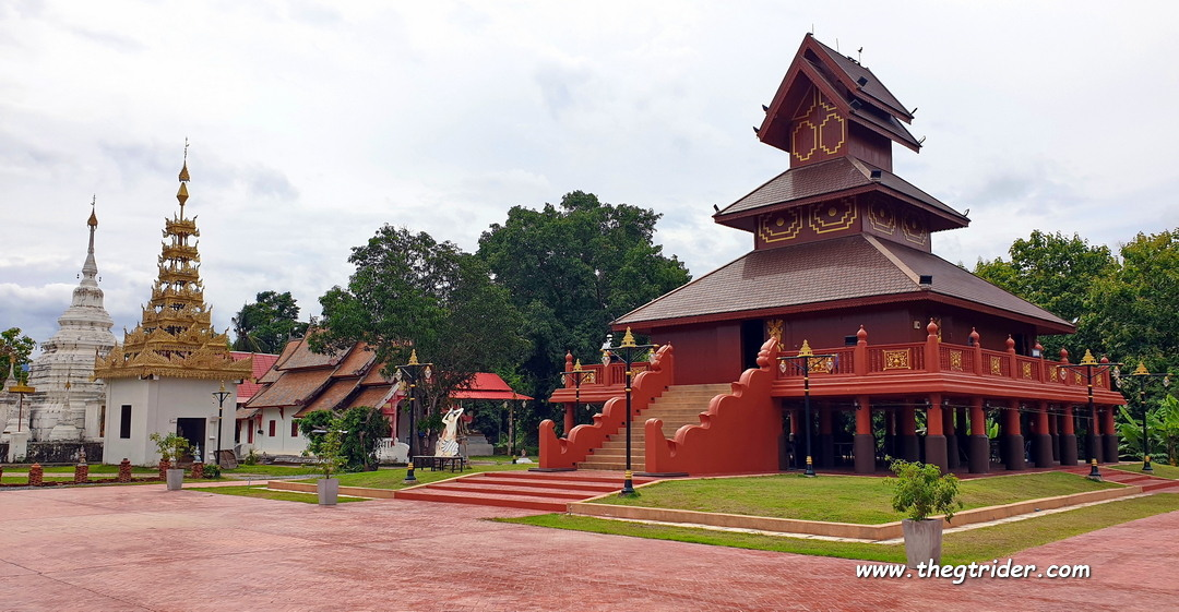
En route to Phrae we hit the Wiang Ta Mon temple that featured in Jurgen's beautiful Tai Lue Murals report.

1623766059004-png.141825


Day 2: ride back out of Phrae on the magnificent R1023

1624549608872.png


1624549639667.png


The 1st station was the Ban Pin railway station that has featured on GTR here before

This fabulous railway station is just 950 metres off R1023 & so with Dave DKT not able to resist another look at this classic train station, we swung on by for a few pics.
On our previous visit we had wondered about a couple of pics on the platform, so for round 2 at Ban Pin it was on...
1624550059183.png


1624550097763.png


1624550124817.png


1624550142460.png


Some Ban Pin station info
Ban Pin Railway Station is a classic beauty and was built by the Geman engineer Emil Eisenhofer, who built the Khun Tan railway tunnel.
The building is a combination of Northern Thai architecture and European architecture of a “Bavarian Timber Frame House” that was favoured in Bavaria, Germany.
The Station is somewhat unique with a small two-storey office building adorned with exquisite perforated fretwork woodcarvings on the window and door frames. The classic charming design of the Station makes it among Thailand’s six significant railway stations.
The Ban Pin station was opened on 15 June 1914.


More to come....... further on down the line.
 
Last edited:
  • Like
Reactions: Ian Bungy

DavidFL

0
Staff member
Subscribed
Jan 16, 2003
14,428
5,260
113
70
Chiang Khong
www.thegtrider.com
The delightful amphur of Long is situated just off R1023, 4.5 kms west of Ban Pin.


Ride through Long & there are a couple of roads that link up with R11, south of the R1023 / R11 junction.
Long looks like a really cool little town & maybe a possibility for a future GTR dinner, once the covid-19 coast clears.
R2015 is the route number you need to pick up going out of Long.

It is a truly gorgeous winding rural back road with some fabulous traditional charming villages & is definitely worthy of a ride sometime if you are in the area.

4 kms S-W of Long it runs alongside the Yom river for a short distance.

1624551223993.png


Another 1.6 kms further on it crosses the Yom.
1624551375022.png


1624551394997.png


1624551410974.png


1624551428923.png


500 metres off R11 is a enchanting little forest garden & stream beside the road.
1624552541748.png


1624552558377.png


1624552584470.png


Once you hit the R11 it is all downhill, especially on the amazing run into the Kaeng Lung railway station.
The rain was drizzling & there were multiple trailer trucks on the slippery descent, such that it was quite daunting.

The route number is R2017 & it goes like this!

1624553453828.png


Straight down onto the Yom River.

The Kaeng Luang Station & what a gem it is backing straight onto the Yom River.
1624553982631.png


1624554885778.png


1624554901147.png


1624554918058.png


1624554935234.png


1624554975325.png


1624555086811.png


1624555107113.png


The super friendly staff let Dave DKT go & play at pulling levers
1624555120568.png


The room was a classic with the old equipment
1624555208812.png


1624555239741.png


1624555261861.png


1624555282960.png


1624555299612.png


1624555626759.png


Of note for Kaeng Luang is that there is an option to take another road on the east side of the Yom river back into Long.
Something to explore on the next trip. The route numbers should be 3043, 2007 & 2067. The Yom keeps calling...

3 more stations down the line to come.....

1624556146858.png
 

DavidFL

0
Staff member
Subscribed
Jan 16, 2003
14,428
5,260
113
70
Chiang Khong
www.thegtrider.com
Some light rain & drizzle continues but the two intrepid rail riders continue on in their hunt.
It is 22 kms from Kaeng Luang to the next stop Den Chai city.

Den Chai is a major station in the North, & time for a lunch break.
1624609161307.png


Eventually Den Chai city will be the main rail junction for trains going to Chiang Rai - Chiang Saen - Chiang Khong, if they ever get the fast track / high speed rail line built.

1624609203069.png


1624609222660.png


1624609255475.png


1624609273971.png


1624609292966.png


1624609316616.png


Den Chai is 3.7 kms south west of the Yom river, & 4.5 kms north up the rail line is Pak Pan railway station.
To get there is a round about way, & as luck would have we got a bit confused & ended up under a bridge that the rail line was on.

1624613901130.png


Too funny & unplanned, wouldn't it be an experience to be under the line as the train passed over. What a dirty selfie that would be?
1624613885137.png


1624613856832.png


80 metres later we ended up on the right road, turned left & rode into the Pak Pan station.
1624616382828.png


1624617089820.png


1624617135468.png


1624617066144.png

Standing out by the track Dave DKT says, can you hear the train coming?
Nah, BS, if there's train coming we should be under that bridge for a selfie, not here!
And then...
1624617251691.png


1624617267532.png


Bye guys you missed out
1624617293495.png


The railway station to the bridge is 420 metres.
Next trip we will time our run to be under that bridge for the experience!

Pak Pan station

Moving on down the line next,...the fabulous Mae Phuak station.
 
Last edited:

DavidFL

0
Staff member
Subscribed
Jan 16, 2003
14,428
5,260
113
70
Chiang Khong
www.thegtrider.com
10.3 kms "south" down the rail line from Pak Pan is Mae Phuak / 6 kms from Den Chai.
By road it is 14 kms. One needs to get onto R11 & head towards Uttaradit.
3.5 kms from the junction of R101 / 11, there's a tricky turn off to the right.

Make the turn & follow the narrow bumpy lane through the village & you can see the railway line & a few buildings across a deserted car park.
1624625199902.png


The Mae Phuak station.
1624625134291.png


Our interest in the Mae Phuak station was alerted by this 2018 Bangkok Post article

No longer in use as a railway station it had been turned into a homestay, come museum.
Sadly covid-19 seems to have taken its toll here too.

1624625389037.png


Some magic old photos & belles
1624625459368.png


1624625549337.png


1624625621994.png


1624625706838.png


1624625832616.png


Unfortunately soon after this, the rain set in & with tropical storm Koguma inbound we abandoned the planned exploratory ramble down to Phichit. So with no rain gear for the old GTR fellah we set of North & home.
Lampang it was for the night & a test munch on Long Jim's famed pizzas.

The old GTR Fellah with a small "Fat Bastard" pizza
1624626289817.png


Young Nong Dave with his & some fermented coffee
1624626370267.png


Long may the good times roll.
Riding is the best therapy in these difficult times.

For some more interesting info on the old stations
 

DavidFL

0
Staff member
Subscribed
Jan 16, 2003
14,428
5,260
113
70
Chiang Khong
www.thegtrider.com
One last "post mortem" almost.

The next day's ride from Lampang was wet all the way & the old fellah had no rain gear but decided to tough it out & ride straight through Lampang - Chiang Khong non-stop.
There was one fuel stop, just north of Phayao & then power on.
Towards Chiang Rai the rain lightened right up & it got considerably cooler with blustery winds around the western bypass R131.
Back on R1063 & the homeward straight, some light rain kept falling, and with a cool breeze blowing I started to get chilled right through, losing some feeling in my hands. Don't stop though, let's get home, power on. It was a bit of as shock then when I looked down at my speedo & noticed I was doing 155KPH. Oops, didn't think I was going that fast in the wet.
Now back at home I downloaded my GPS track & note that I hit 162KPH.

1624639740750.png


It's good to be alive - I don't plan on going that fast in the wet again.
 
Last edited:
  • Like
Reactions: Ian Bungy

DavidFL

0
Staff member
Subscribed
Jan 16, 2003
14,428
5,260
113
70
Chiang Khong
www.thegtrider.com
Phichit Railway Station

Phichit city is a provinical capital of the province with the same name.
The city lays south of Phitsanulok, west of R11, between the Nan & Yom Rivers, which join 80 kms south as the Nan, to flow onto Nakhon Sawan to form the Chao Praya river with the Ping River.

Known as the land of the crocodiles, Phichit has a legend that tells of Chalawan, the powerful crocodile king.

East of Phichit city, across the Nan River, is the provincial railway station & what a little classic it is.
1630432301453.jpeg


1630432319586.jpeg


1630432338113.jpeg


1630432369801.jpeg


1630432392732.jpeg


1630432412108.jpeg


1630432424828.jpeg


1630433631070.jpeg


Last edited:

DavidFL

0
Staff member
Subscribed
Jan 16, 2003
14,428
5,260
113
70
Chiang Khong
www.thegtrider.com
Taphan Hin Railway station
The station opened on 24 January 1908 as part of the Northern Line extension from Pak Nam Pho (Nakhon Sawan) to Phitsanulok.

1631765543135-png.143294


Taphan Hin, was once the largest city in Phichit & all the trains stopped in Taphhan Hin, but when Phichit City grew bigger than Taphan Hin, most of the trains missed Taphan Hin.
1631765575151-png.143295


1631765597439-png.143296


1631765623216-png.143297


DavidFL

0
Staff member
Subscribed
Jan 16, 2003
14,428
5,260
113
70
Chiang Khong
www.thegtrider.com
The confluence of the Yom & Nan rivers

From

1631775042781.png


1631775055432.png


1631775066127.png


DavidFL

0
Staff member
Subscribed
Jan 16, 2003
14,428
5,260
113
70
Chiang Khong
www.thegtrider.com
Riding home from the GTR Dinner in Si Satchanalai it was time to tick off another couple of roads & places on the Yom out of Long city.

Wat Phrathat Laem Si was my first destination.
1642519535174.jpeg


The wat sits on a big oxbow bend in the Yom River.
1642517955556.jpeg


Wat Phrathat Laem Si is an ancient important wat with 5 important Buddha images.
The main image is a reclining Buddha, Phra Wewa.
1642521262912.jpeg


1642519675221.jpeg


Located in a large elongated oxbow of the Yom, there is an annual merit making ceremony, where villagers come by boat on the Yom to pay homage to the God Vatthaphat, the God of the Martyrs, and the God of Rain at the temple.

The steps from the Yom river to the temple.
1642519697058.jpeg

GTR is interested to witness this old traditional boat merit making ceremony one day.

History
When the Buddha attained enlightenment, he came to preach the Dharma "Saramma Chitta Sutta", and when the Buddha had passed away for 220 years, Phraya Sri Thammasoka the Great, along with 400 arhat monks, brought the Buddha's relics to be contained. Since then, around 949 B.E. Phraya Brahmakul was the ruler of Wevaphasat (Long District) in those days, and Alaiyaramo had Phraya Minaya as the ruler of Thung Yang. Phraya Changko was the ruler of Fang Phraya Sirisutthawangsa is the ruler of Lawo City (Lop Buri); and they all had become friends and built Phra That Laem Li. Therefore, Phra That Laem Li is a sacred place in Thailand Or, in the world, that is to say, there are five Buddhas, namely Kakusandha, Konagamana, Kassapa, Gotama, and Ariyamataya to show the name "Saramma Chitta Sutta" everyone, so this Laem Li temple So it's amazing. If anyone comes to pay homage here, it is as if we have paid homage five gods, there is no merit that can be compared.

Source: Thailand Tourism Directory - Digital Tourism

1642519761750.jpeg


1642519799269.jpeg


1642519781610.jpeg


1642519816639.jpeg


There are also two old chedis Phrathat Noi and Phrathat Laem Li.
The chedis
1642520038247.jpeg


1642520055388.jpeg


1642520075498.jpeg


1642520291556.jpeg


1642520384961.jpeg


1642520411193.jpeg


1642520457727.jpeg


1642520482324.jpeg


An old 200 year ordination hall houses some very old Buddhas.
1642520501805.jpeg


1642520583450.jpeg


1642520773402.jpeg


Some old Buddhas
1642520700977.jpeg


1642520749259.jpeg


1642520844649.jpeg


1642520882294.jpeg


A model of the site
1642520942854.jpeg


1642521005524.jpeg


1642521950438.jpeg


Check it out sometime.
 
Last edited:
  • Like
Reactions: Ian Bungy

DavidFL

0
Staff member
Subscribed
Jan 16, 2003
14,428
5,260
113
70
Chiang Khong
www.thegtrider.com
Si Satchanalai April 2022 - Buat Chang / Monks Ordination festival.

Si Satchanlai has an annual monks ordination festival, where the young novice monks to be are paraded around town on elephant back.
One of the highlights late in the day, is the elephants wading in the Yom River.

1649573033055.jpeg


1649573258710.jpeg


1649573143536.jpeg


1649573489177.jpeg


1649573361174.jpeg


1649573601367.jpeg
 
  • Like
Reactions: Ian Bungy

DavidFL

0
Staff member
Subscribed
Jan 16, 2003
14,428
5,260
113
70
Chiang Khong
www.thegtrider.com
Sawankhalok Railway Station - Sawankhalok attractions.
1675766337035.jpeg


The Sawankhalok railway station & line is a sideline from off the main rail Bangkok - north line.

1675766382902.jpeg


It links up at

It was built by King Rama V in honour of one of his wives who was from Sawankhalok, and opened on the 15th August 1910.
1675766409703.jpeg


The station is a Class 3 Station and is located 487.14 kilometres (302.7 mi) from Bangkok railway station.
Notably this station uses signs as signals instead of lighted poles or semaphores and is operated manually.

1675766438232.jpeg


It is one of the two stations on the Northern Line that uses this signalling system, the other being Khlong Maphlap railway station, the preceding station.

1675766481424.jpeg


The station is the terminus of the Sawankhalok Branch from Ban Dara Junction.

1675766511811.jpeg


Some old scales at the station.
1675791041839.jpeg


In olden days people from Tak, Sukhothai, & Kamphaeng Phet would travel to Sawankhalok to catch the train to Bangkok.
Sawankhalok was an important halfway stop on the Bangkok - Chiang Mai rail line for steam engines to top up, & there is an old well by the railway station that supplied the water.

1675766973248.jpeg


The station has an old coffee shop that is a classic, with its "muang boran coffee."
1675791178997.jpeg


1675791196856.jpeg


See also

 
Last edited:

DavidFL

0
Staff member
Subscribed
Jan 16, 2003
14,428
5,260
113
70
Chiang Khong
www.thegtrider.com
February 2024
2024 & playing catch up still after my accident 21 months ago - how time flies - back in Phrae fossicking around for new attractions & following the Yom.
I was chasing a suspension bridge over the Yom River where a lady driver in her car following her GPS got stuck on the Yom where she shouldn't have been.
1707389665304.png


How could you possibly do that I thought?

A search of google earth in the "offending town" of Sung Men turned up what looked like a possibility for me.
1707396773637.jpeg


However my close inspection made me think nah, it's not this one.
1707396876298.jpeg


She couldn't have driven out onto this one, surely not?
Or did she try from the other bank, on the west side?
1707397048461.jpeg


1707396895720.jpeg


1707397121851.jpeg


So back at home I now see this one
and if you zoom in on google earth stret view on the East bank, you can see a scooter riding across the bridge.
Could this be the one?
I'm still undecided & need to take another look.

Should go again you could try this coffee shop by the first bridge